All aboard for security

With France’s rail transport market opening up to competition, the SNCF’s security work is also becoming a service. This transformation raises questions on how security as an activity is organized. Florent Castagnino, Sociology researcher at IMT Atlantique, has studied how this service can adapt.  

2021 saw private train companies newly authorized to operate on French rails, previously monopolized by the SNCF. As well as opening its rail system to the competition, the state-owned company plans to offer security services to other companies. In the railway sector, “security is defined as the prevention of antisocial acts such as theft, fraud, attacks and assaults, whereas safety relates to the prevention of accidents such as issues with points or signals,” indicates Florent Castagnino, sociology researcher at IMT Atlantique.

While security is a preventive activity, it is also a commercial one. With the market opening up to competition, security services are sure to also become a profitable venture. This raises the question of whether a company prepared to pay more than another could obtain better security provision for its journeys and routes. Furthermore, with security guards in train stations, a company will not only regulate acts of malevolence but also reassure passengers. “Even if the trains are secure, a company may wish for agents to patrol the platform or on the train to enhance its brand image,” states Castagnino.

However the sale of security services to competing companies is a challenge for the distribution of agents across France. While certain stations or regional train lines may wish to purchase such services, they might not have access if there is too much demand from other companies or in other regions. Even if the SNCF security department is one of the departments that increases its workforce most regularly, “the question arises of how decisions will be made,” explains the researcher.

Representing complex problems

The distribution of personnel across the country represents a challenge due to the limited number of agents, but it also shows that delinquency is handled purely geographically. Analysis of databases of police reports and calls to emergency services from railway patrols and workers reveals the frequency of malicious acts, their nature and the place in which they occur. Using this information, patrols are sent to stations with the highest number of criminal acts reported.

Typically, if there are more malicious acts reported on line A than line B, more agents will be sent to line A. In this case, database analysis automatically ignores the multiple, complex origins of delinquency, focusing only on the phenomenon’s geographic aspect. As causes of delinquency are considered external to railway companies, they cannot take action as easily as for safety issues, which often have causes considered internal. This means that they are simpler to identify and resolve.

For Castagnino, making use of “databases for delinquency prevention means we imitate the way we handle accidental problems”. From the 90s, “there was a desire to make security more concrete, partly by using a model for the way in which we manage accidents,” continues the researcher.“This can be explained by the decision to apply the methods that work in one area, here safety, to another, in this case, security,” he adds. In the case of safety, if a technical fault such as a signaling failure is regularly reported on a certain kind of equipment, maintenance agents will be sent to repair the traffic lights on the railways concerned, and a general servicing of the equipment may be ordered. For security, if there is a station with many incidents reported, agents from the security department may be sent to the site to address the delinquency problem.

Regulatory surveillance

Most of the time, agents perform rounds to control delinquency. Their simple presence is generally enough to calm potentially disruptive groups. In train stations, “security guards self-regulate and expect social groups to do the same,” explains Castagnino. In a way, they serve as an anchor for groups to control themselves. If that does not work, the security forces can intervene to regulate them. The young researcher calls this process ‘regulatory surveillance’.

If for example, in a station, one or several individuals from a group start to bother someone, the other members of the group will often return them to order, in particular to maintain their collective right to remain in the station, which is seen as an important relational link. Regulatory surveillance also concerns military security forces. They sometimes operate in the same stations regularly, which means they get to know the groups that hang around inside. If a new agent is tempted to act aggressively without a clear reason, their colleagues (who know the place) can dissuade them, explaining that their intentions are disproportionate in relation to the group’s actions. This kind of relationship makes it possible to preserve good relations between agents and civilians.

In recent decades, several terrorist attacks in trains (Madrid in 2004, London in 2005, Thalys in 2015) have raised the question of introducing airport safety measures to the rail system. In particular, SNCF has brought in certain practices used in airports, such as the use of metal detectors in certain stations (particularly for Thalys trains). France’s national railway company is constantly working on an approach to the objectification of security threats, and seeking to make use of advantages provided by new technological tools.

Rémy Fauvel

[box type=”shadow” align=”” class=”” width=””]

Improving surveillance through automatic recognition?

Projects are currently underway to equip surveillance cameras with automatic image processing software. This would allow them to recognize suspicious behavior. “For now, these techniques are sub-optimal,” points out Castagnino. Certain cameras “don’t work or don’t have good video quality, specifically because they are too old,” indicates the researcher. To implement this technology, the camera fleet will therefore need to be updated.

[/box]

[box type=”shadow” align=”” class=”” width=””]

Challenges to the SNCF in the 21st century

Castagnino’s research on rail systems is published in “La SNCF à l’épreuve du XXIe siècle”, a collective work that discusses shifts in the French railway system and its recent evolution from a historic perspective.

[/box]

MuTAS, urban mobility

“En route” to more equitable urban mobility, thanks to artificial intelligence

Individual cars represent a major source of pollution. But how can you transition from using your own car when you live far from the city center, in an area with little access to public transport? Andrea Araldo, researcher at Télécom SudParis is undertaking a research project that aims to redesign city accessibility, to benefit those excluded from urban mobility.

The transport sector is responsible for 30% of greenhouse gas emissions in France. And when we look more closely, the main culprit appears clearly: individual cars, responsible for over half of the CO2 discharged into the atmosphere by all modes of transport.

To protect the environment, car drivers are therefore thoroughly encouraged to avoid using their car, instead opting for a means of transport that pollutes less. However, this shift is impeded by the uneven distribution of public transport in urban areas. Because while city centers are generally well connected, accessibility proves to be worse on the whole in the suburbs (where walking and waiting times are much longer). This means that personal cars appear to be the only viable option in these areas.

The MuTAS (Multimodal Transit for Accessibility and Sustainability) project, selected by the National Research Agency (ANR) as part of the 2021 general call for projects, aims to reduce these accessibility inequalities at the scale of large cities. The idea is to provide the keys to offering a comprehensive, equitable and multimodal range of mobility options, combining public transport with fixed routes and schedules with on-demand transport services, such as chauffeured cars or rideshares. These modes of transport could pick up where buses and trains leave off in less-connected zones. “In this way, it is a matter of improving accessibility of the suburbs, which would allow residents to leave their personal car in the garage and take public transport, thereby contributing to reducing pollution and congestion on the roads”, says Andrea Araldo, researcher at Télécom SudParis and head of the MuTAS project, but formerly a driving school owner and instructor!

Improving accessibility without sending costs sky-high

But how can on-demand mobility be combined with the range of public transport, without leading to overblown costs for local authorities? The budget issue remains a central challenge for MuTAS. The idea is not to deploy thousands of vehicles on-demand to improve accessibility, but rather to make public transport more equitable within urban areas, for an equivalent cost (or with a limited increase).

This means that many questions must be answered, while respecting this constraint. In which zones should on-demand mobility services be added? How many vehicles need to be deployed? How can these services be adapted to different times throughout the day? And there are also questions regarding public transport. How can bus and train lines be optimized, to efficiently coordinate with on-demand mobility? Which are the best routes to take? Which stations can be eliminated, definitively or only at certain times?

To resolve this complex optimization issue, Araldo and his teams have put forward a strategy using artificial intelligence, in three phases.

Optimizing a graph…

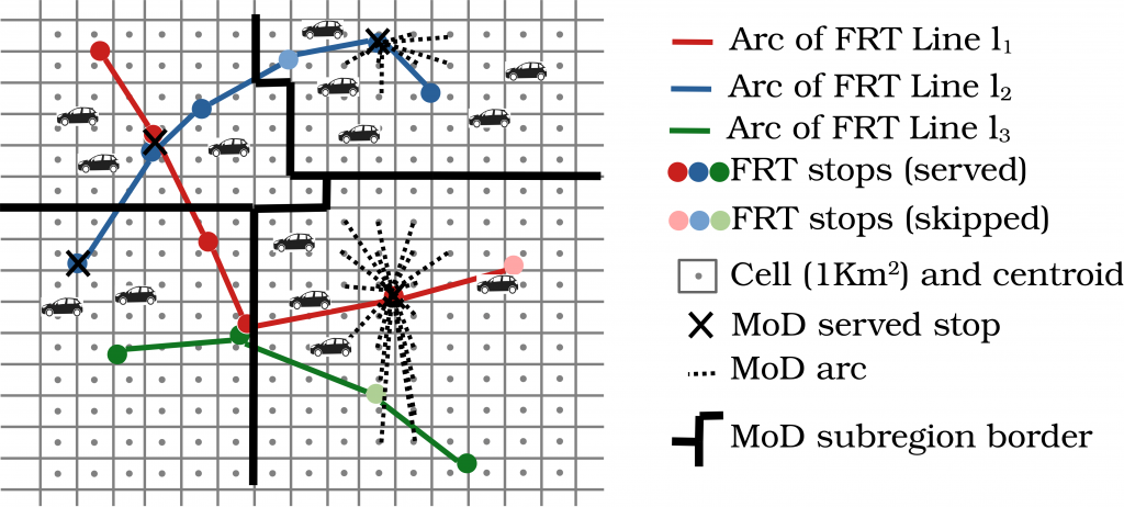
The first involves modeling the problem in the form of a graph. In this graph, the points correspond to bus stops or train stations, with each line represented by a series of arcs, each with a certain trip time. “What must be noted here is that we are only using real-life, public data,” emphasizes Araldo. “Other research has been undertaken around these issues, but at a more abstract level. As part of MuTAS, we are using openly available, standardized data, provided by several cities around the world, including routes, schedules, trip times etc., but also population density statistics. This means we are modeling real public transport systems.” On-demand mobility is also added to the graph in the form of arcs, connecting less accessible areas to points in the network. This translates the idea of allowing residents far from the city center to get to a bus or train station using chauffeured cars or rideshares.

L’attribut alt de cette image est vide, son nom de fichier est Schema-1024x462.png.
To optimize travel in a certain area, researchers start by modeling public transport lines with a graph.

…using artificial intelligence

This modeled graph acts as the starting point for the second phase. In this phase, a reinforcement learning algorithm is introduced, a method from the field of machine learning. After several iterations, this is what will determine what improvements need to be made to the network, for example, deactivating stations, eliminating lines, adding on-demand mobility services, etc. “Moreover, the system must be capable of adapting its structure dynamically, according to shifts in demand throughout the day,” adds the researcher. “The traditional transport network needs to be dense and extended during peak hours, but it can contract significantly in off-peak hours, with on-demand mobility taking over for the last kilometers, which is more efficient for lower numbers of passengers.”

And that is not the only complex part. Various decisions influence each other: for example, if a bus line is removed from a certain place, more rideshares or chauffeured car services will be needed to replace it. So, the algorithm applies to both public transport and on-demand mobility. The objective will therefore be to reach an optimal situation in terms of equitable distribution of accessibility.

But how can this accessibility be evaluated? There are multiple methods to do so, but researchers have chosen two adapted methods for graph optimization. The first is a ‘velocity score’, corresponding to the maximum distance that can be traveled from a departure point in a limited time (30 minutes for example). The second is a ‘sociality score’, representing the number of people that one can meet from a specific area, also within a limited time.

In concrete terms, the algorithm will take an indicator as a reference, i.e. a measure of the accessibility for the least accessible place in the area. The aim being to make transport options as equitable as possible, it will aim to optimize this indicator (‘max-min’ optimization), while respecting certain restrictions such as cost. To achieve this, it will make a series of decisions concerning the network, initially in a random way. Then, at the end of each iteration, by analyzing the flow of passengers, it will calculate the associated ‘reward’, the improvement in the reference indicator. The algorithm will then stop when the optimum is reached, or else after a pre-determined period.

This approach will allow it to establish knowledge of its environment, associating each network structure (according to the decisions made) with the expected reward. “The advantage of such an approach is that once the algorithm is trained, the knowledge base can be used for another network,” explains Araldo. “For example, I can use the optimization performed for Paris as a starting point for a similar project in Berlin. This represents a precious time-saver compared to traditional methods used to structure transport networks, in which you have to start each new project from zero.”

Testing results on (virtual) users in Ile-de-France

Lastly, the final phase aims to validate the results obtained using a detailed model. While the models from the first phase aim to reproduce reality, they only represent a simplified version. This is important, given that they will then be used for various iterations, as part of the reinforcement learning process. If they had a very high level of detail, the algorithm would require a huge amount of computing power, or too much processing time.

The third phase therefore involves first delicately modeling the transport network in an urban area (in this case, the Ile-de-France region), still using real-life data, but more detailed this time. To integrate all this information, researchers use a simulator called SimMobility, developed at MIT in a project to which Araldo contributed. The tool makes it possible to simulate the behavior of populations at an individual level, each person represented by an ‘agent’ with their own characteristics and preferences (activities planned during the days, trips to take, desire to reduce walking time or minimize number of changes, etc.). ‎It was based on the work of Daniel McFadden (Nobel Prize for Economics in 2000) and Moshe Ben-Akiva on ‘discrete choice models’, which makes it possible to predict choices between multiple modes of transport.

With the help of this simulator and public databases (socio-demographic studies, road networks, numbers of passengers, etc.), Araldo and his team, in collaboration with MIT, will generate a synthetic population, representing Ile-de-France users, with a calibration phase. Once the model faithfully reproduces reality, it will be possible to submit it to the new optimized transport system and simulate user reactions. “It is important to always remember that it’s only a simulation,” reminds the researcher. “While our approach allows us to realistically predict user behavior, it certainly does not correspond 100% to reality. To get closer, more detailed analysis and deeper collaborations with transport management bodies will be needed.”

Nevertheless, results obtained could serve to support more equitable urban mobility and in time, reduce its environmental footprint. Especially since the rise of electric vehicles and automation could increase the environmental benefits. However, according to Araldo, “electric, self-driving cars do not represent a miracle solution to save the planet. They will only prove to be a truly eco-friendly option as part of a multimodal public transport network.”

Bastien Contreras

La Ruche à vélos, bicycle parking

La Ruche à Vélos is developing secure bicycle parking throughout France

Innovative and appropriate parking solutions must be created for the long-term development of cycling. The La Ruche à Vélos start-up incubated at IMT Atlantique offers an automated, secure and easy-to-use parking facility. This modular concept is connected to a mobile application and is intended for all users via acquisition by local authorities. For this solution, La Ruche à Vélos won the 2020 Bercy-IMT Innovation Award on February 2nd.

In 2020, many French people got back on their bikes. In its annual report published last October, the Vélo & Territoires association reported an average increase in bicycle use of 9% between January and September 2020 (compared to 2019) [1]. In a year strongly marked by strikes and the health crisis, exceptional circumstances strongly supported this trend. The attraction for bicycles shows no signs of slowing down. While local authorities support these practices, they also raise new issues in terms of security and parking. How many cyclists have already found their bike without a saddle, without a wheel, or perhaps not found their bike at all? To meet these challenges, the start-up La Ruche à Vélos, incubated at IMT Atlantique, proposes an innovative secure bicycle storage solution.

Automatic and secure parking

The increase in the number of cyclists is due in part to the emergence of electric bicycles. These bikes are heavier, bulkier and require a significant financial investment by their users. They therefore pose new constraints and require more security when parking. La Ruche à Vélos has developed a product that meets these expectations. Their solution consists of a secure bicycle parking facility which is connected to a mobile application. Its three founders were particularly attached to its ease of use. “It takes between 20 and 30 seconds to drop off or pick up a bike,” says Antoine Cochou, co-creator of the start-up. But how does it work?

The application allows the user to geolocate a parking facility with available spaces and to reserve one in advance. After identifying themselves on site, cyclists have access to a chamber, and deposit their bike on a platform before validating. There are also compartments available allowing users to recharge their batteries. Inside the parking facility, a machine stores the bike automatically. The facility covers several floors, thus saving ground space and facilitating integration of the system into the urban landscape. It can hold about 50 bikes over 24 square meters, dividing the bicycle parking space otherwise required on sidewalks by four! In addition, the size of the parking facility is flexible. The number of spaces therefore varies according to the order.

In June 2021, a first prototype of about ten spaces will be installed in the city of Angers. The young innovators hope to collect enough feedback from users to improve their next product. Two more facilities are planned for the year. They will have 62 to 64 spaces. “Depending on the location, a balance must be struck between user waiting time and the demand for services. These two parameters are related to the number of sites and the flow of users at peak times (train station, shops, etc.),” says Antoine Cochou.

Strategic locations with adapted subscriptions

La Ruche à Vélos is aimed directly at local authorities who can integrate this solution into their mobility program. It also targets businesses and real estate developers wishing to offer an additional service to their employees or future residents. Depending on the needs, the parking facilities could therefore be installed in different strategic locations. “Local authorities are currently focusing on railway stations and city centers, but office or residential areas are also being considered,” says Antoine Cochou. Each zone has its own target and therefore its own form of subscription. In other words, one-off parking in the city, daytime offers for offices, and evening and weekend passes for residents.

Initially, subscriptions for the prototype installed in Angers will be managed by the start-up. However, future models are expected to couple parking passes with local public transit passes. Subscriptions will thus be taken care of by the cities. The start-up will focus on maintenance support. “In this sense, our next models will be equipped with cameras and it will be possible to control them remotely,” says Maël Beyssat, co-creator of La Ruche à Vélos. Communities will have a web interface to monitor the condition and operating status of the parking facility (rate of use, breakdowns, availability, etc.)

For the future, the company is considering the installation of solar panels to offer a zero-electricity consumption solution. Finally, other locations could be considered outside of popular touring sites on cycle routes.

[1] Result obtained with the help of sensors measuring the number of bikes going past.

By Anaïs Culot

New multicast solutions could significantly boost communication between cars.

Effective communication for the environments of the future

Optimizing communication is an essential aspect of preparing for the uses of tomorrow, from new modes of transport to the industries of the future. Reliable communications are a prerequisite when it comes to delivering high quality services. Researchers from EURECOM, in partnership with The Technical University of Munich are working together to tackle this issue, developing new technology aimed at improving network security and performance.


In some scenarios involving wireless communication, particularly in the context of essential public safety services or the management of vehicular networks, there is one vital question: what is the most effective way of conveying the same information to a large number of people? The tedious solution would involve repeating the same message over and over again to each individual recipient, using a dedicated channel each time. A much quicker way is what is known as multicast. This is what we use when sending an email to several people at the same time, or when a news anchor is reading us the news. The sender of the information only provides it once, disseminating it via a means enabling them to duplicate it and to send it through communication channels capable of reaching all recipients.

In addition to TV news broadcasts, multicasts are particularly useful for networks comprising machines or objects set to follow on from the arrival of 5G and its future applications. This is the case, for example, with vehicle networks. “In a scenario where cars are all connected to one another, there is a whole bunch of useful information that could be shared with them using multicast technology”, explains David Gesbert, head of the Communication Systems department at EURECOM. “This could be traffic information, notifications about accidents, weather updates, etc.” The issue here is that, unlike TV sets, which do not move about while we are trying to watch the news, cars are mobile.

The mobile nature of recipients means that reception conditions are not always optimal. When driving through a tunnel, behind a large apartment block or when we’re taking our car out of the garage, it will be difficult for communication to reach our car. Despite these constraints – which affect multiple drivers at the same time – we need to be able to receive messages in order for the information service to operate effectively. “The transmission speed of the multicast has to be slowed down in order for it to be able to function with the car located in the worst reception scenario”, explains David Gesbert. What this means is that the flow rate must be lower or more power deployed for all users of the network. Just 3 cars going through a tunnel would be enough to slow down the speed at which potentially thousands of cars receive a message.

Communication through cooperation

For networks with thousands of users, it is simply not feasible to restrict the distribution characteristics in this way. In order to tackle this problem, David Gesbert and his team entered into a partnership with the Technical University of Munich (TUM) within the framework of the German-French Academy for the Industry of the Future. These researchers from France and Germany set themselves the task of devising a solution for multicast communication that would not be constrained by this “worst car” problem. “Our idea was as follows: we restrict ourselves to a small percentage of reception terminals which receive the message, but in order to offset that, we ensure that these same users are able to retransmit the message to their neighbors”, he explains. In other words: in your garage, you might not receive the message from the closest antenna, but the car out on the street 30 feet in front of your house will and will then be able to send it efficiently over a short distance.

Researchers from EURECOM and the TUM were thus able to develop an algorithm capable of identifying the most suitable vehicles to target. The message is first transmitted to everyone. Depending on whether or not reception is successful, the best candidates are selected to pass on the rest of the information. Distribution is then optimized for these vehicles through the use of the MIMO technique for multipath propagation. These vehicles will then be tasked with retransmitting the message to their neighbors through vehicle to vehicle communication. The tests carried out on these algorithms indicate a drop in network congestion in certain situations. “The algorithm doesn’t provide much out in the country, where conditions tend mostly to be good for everyone”, outlines David Gesbert. “In towns and cities, on the other hand, the number of users in poor reception conditions is a handicap for conventional multicasts, and it is here that the algorithm really helps boost network performance”.

The scope of these results extends beyond car networks, however. One other scenario in which the algorithm could be used is for the storage of popular content, such as videos or music. “Some content is used by a large number of users. Rather than going to search for them each time a request is made within the core network, these could be stored directly on the mobile terminals of users”, explains David Gesbert. In this scenario, our smartphones would no longer need to communicate with the operator’s antenna in order to download a video, but instead with another smartphone with better reception in the area onto which the content has already been downloaded.

More reliable communication for the uses of the future

The work carried out by EURECOM and the TUM into multicast technology has its roots in a more global project, SeCIF (Secure Communications for the Industry of the Future). The various industrial sectors set to benefit from the rise in communication between objects need reliable communication. Adding machine-to-machine communication to multicasts is just one of the avenues explored by the researchers. “At the same time, we have also been taking a closer look at what impact machine learning could have on the effectiveness of communication”, stresses David Gesbert.

Machine learning is breaking through into communication science, providing researchers with solutions to design problems for wireless networks. “Wireless networks have become highly heterogeneous”, explains the researcher. “It is no longer possible for us to optimize them manually because we have lost the intuition in all of this complexity”. Machine learning is capable of analyzing and extracting value from complex systems, enabling users to respond to questions that are too difficult to understand.

For example, the French and German researchers are looking at how 5G networks are able to optimize themselves autonomously depending on network usage data. In order to do this, data on the quality of the radio channel has to be fed back from the user terminal to the decision center. This operation takes up bandwidth, with negative repercussions for the quality of calls and the transmission of data over the Internet, for example. As a result, a limit has to be placed on the quantity of information being fed back. “Machine learning enables us to study a wide range of network usage scenarios and to identify the most relevant data to feed back using as little bandwidth as possible”, explains David Gesbert. Without machine learning “there is no mathematical method capable of tackling such a complex optimization problem”.

The work carried out by the German-French Academy will be vital when it comes to preparing for the uses of the future. Our cars, our towns, our homes and even our workplaces will be home to a growing number of connected objects, some of which will be mobile and autonomous. The effectiveness of communications is a prerequisite to ensuring that the new services they provide are able to operate effectively.


[box type=”success” align=”” class=”” width=””]

The research work by EURECOM and TUM on multicasting mentionned in this article has been published during the International Conference on Communications (ICC). It received the best paper award (category: Wireless communications) during the event, which is a highly competitive award in this scientific field.

[/box]

mobility

20 terms for understanding mobility

Increasingly linked to digital technology, mobility is becoming more complex and diversified. Autonomous driving, multimodality, rebound effect and agile method are all terms used in the study of new forms of mobility. The Fondation Mines-Télécom has put together a glossary of 20 terms to help readers understand the issues involved in this transformation and clarify the ideas and concepts explained in its 10th booklet.


Active mobility A form of transport that uses only the physical activity of the human being for locomotion. Cycling, walking, roller skating, skateboarding etc.

Agile development Use of agile methods to create projects based on iterative, incremental and adaptive development cycles.

API  Application programming interface. A set of methods and tools through which a software program provides services to other software programs.

Ergonomics Scientific study of the relationship between human beings and their work tools, methods and environment. Its aim is to develop systems that provide maximum comfort, safety and efficiency.

Explanation interviews Interviews aimed at establishing as detailed a description as possible about a past activity.

Flooding Availability of more resources than necessary.

Free floating Fleet of self-service vehicles available for use without a home station.

Gentrification Urban phenomenon whereby wealthier individuals appropriate a space initially occupied by less privileged residents.

Intermodality Use of several modes of transport during a single journey. Not to be confused with multimodality.

IoT Internet of Things

L4, L5 High levels of autonomous driving. L4: the driver provides a destination or instructions and may not be in the vehicle. L5: Fully autonomous driving in all circumstances, without help from the driver.

MaaS Mobility as a service. This concept was formalized by professionals at the 2014 ITS European Congress in Helsinki and through the launch of the MaaS Alliance.

Modality Used to describe a specific mode of transport characterized by the vehicles and infrastructures used.

Multimodality Presence of several modes of transport between different locations. Not to be confused with intermodality.

PDIE Inter-company travel plan (French acronym for Plan de Déplacement Inter-Entreprise). Helps make individual company travel plans (PDE) more effective by grouping together several companies and pooling their needs.

Rebound effect Economic term explaining the rise in consumption that occurs when the limits of using a technology are reduced.

Soft mobility Sometimes used as an exact synonym for non-motorized (and thereby active) forms of mobility. The term “soft” refers to environmental sustainability relating to eco-mobility: reducing noise, limiting pollution etc. It sometimes also includes motorized or assisted forms of transport based on technologies that do not rely on oil.

Solo car use Term used to describe a driver alone in his/her car.

Transfer An often expensive step during which merchandise or passengers are transferred from one vehicle to another. As short a transshipment as possible is desirable.

TCSP – Acronym used for exclusive right-of-way transit in France.


mobility

Data-mobility or the art of modeling travel patterns

The major rail workers’ strike in France on the spring of 2018 transformed French travel habits, especially in the Ile-de-France region. Vincent Gauthier, a researcher at Télécom SudParis, is working to understand the travel patterns in this region and around the world using mobile data.

[divider style=”normal” top=”20″ bottom=”20″]

The original version of this article (in French) was published on the Télécom SudParis website.

[divider style=”normal” top=”20″ bottom=”20″]

The French have a saying that reflects the daily routine of millions of Parisians: “métro-boulot-dodo” (metro-work-sleep).  While this seems to be the universal experience for Il-de-France residents, individual variations exist. Some individuals only use public transport via one of the two major networks, RATP or SNCF, but others prefer driving. There are also those who change from the metro to the RER train, or leave their car part way and take a train. All of this information can be found through mobile data analysis. Vincent Gauthier, associate research professor at Télécom SudParis, has become a specialist in the area.

Using mobile networks to understand mobility

Determining someone’s travel itinerary based on the mobile data provided by their operator is not an easy task. “A telephone only transmits its GPS position to applications that request it, such as Waze,” Vincent Gauthier explains. “The only knowledge an operator can use to establish a person’s geographic location is which mobile base stations they were connected to during their travels.”

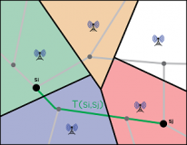
The French telephone network, which is shared between different operators including Orange, SFR and Bouygues, forms an irregular grid pattern (see Fig. 3). The different relay or base stations provide a network connection based on clearly defined zones. When a person leaves a zone, they automatically enter another one, and their telephone connects to the new corresponding base station. The size of these zones varies in each region. In the Ile-de-France region, a large number of base stations are concentrated and clustered together in Paris, but there are much fewer in the Seine-et-Marne region.

[one_half]

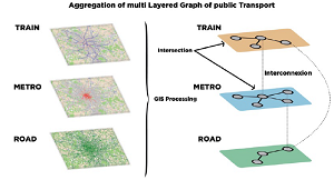
Fig. 1 : Méthode d’agrégation des réseaux de transport pour analyse fine du trajet emprunté.

Fig. 1 : Method used to aggregate the transport networks to closely analyze the route taken.

[/one_half][one_half_last]

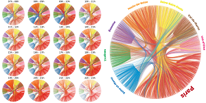
Fig. 2 : Matrice origine-destination sur une journée en Île-de-France.

Fig. 2 : Origin-destination matrix for a day in the Ile-de-France region.

[/one_half_last]

Fig. 3 : Schéma de quadrillage des stations de base du réseau mobile.

Fig. 3 : Grid pattern for the mobile network base stations.


The information produced from these connections only allows origin-destination matrices that are more or less detailed to be established. As an expert in the graphical representation of large volumes of data (Fig. 2), Vincent Gauthier wants to take this analysis a step further: “How does a person travel? Why? Where does the person live? How many other people take the same route? Answering these questions could help us optimize mobility options.”

To reproduce the exact route an individual takes based on this non-specific information, he has worked on a new method with another researcher from Télécom SudParis, Mounim El Yacoubi (ARMEDIA team–EPH department).

From optimizing transportation to geodemographics

Mounim and I have patented a method for automatically processing routes, which allows us to determine what types of transport a person has taken during their journey,” Vincent Gauthier explains. Thanks to their “method for route estimation using mobile data”, the two researchers can superimpose the different transport networks over the information the operators receive from the base stations (Fig. 1). “To identify the most likely road or rail journey the users have taken based on their route, we must use a huge database including the locations of the base stations, train stations and the maps of the different transport networks.” They are currently working with Bouygues to develop route estimations in “near real time”.

In their work, the two researchers are drawing on previous socio-demographic studies they conducted in Milan and in Africa. “We participated in estimating population density in the Ivory Coast and Senegal,” explains Vincent Gauthier. “The goal was to provide socio-demographic data that was lacking in these countries, so that the United Nations could establish more reliable statistics.”

Vincent Gauthier’s work goes beyond simply modeling big data; his expertise leads us to rethink the geography of our regions: “By analyzing individuals’ routes and optimizing transport options accordingly, we could possibly divide the Ile-de-France region into more relevant sub-areas.”