Recovering uranium without digging: in situ leaching

In light of the increasing economic value of underground resources, and the environmental problems caused by disused mines, research into alternative solutions for extracting raw materials is rapidly increasing. One solution being studied is in situ leaching for recovering uranium. During the Natural Resources and Environment conference that took place November 5-6, 2014 at Institut Mines-Télécom, Vincent Lagneau, a researcher at the Mines ParisTech Research Center for Geosciences, presented the results obtained by the “Reactive Hydrodynamics” team in the field of predictive modeling.


In Situ Leaching (ISL) is a process aimed at dissolving metals, such as copper and uranium, which are easily dissolved, directly in the deposit. Using a series of injection and production wells, an acid solution called a lixiviant is injected into the subsoil, then pumped down around ten more meters. “To carry out an in situ leaching operation, a porous, permeable and ideally confined environment is required, explains Vincent Lagneau, a researcher at Mines ParisTech, “the lixiviant solution must be able to circulate while avoiding leaks, which represent both an investment loss and an environmental risk.” At the production wellhead, all that remains is to separate the target minerals from the waste.

This alternative solution is perfect for the uranium deposits that are currently being developed: deep, extended deposits, 10 to 20 kilometers long, with low-grade uranium, that cannot be exploited using open-cast mines or underground mining works. “It has been so successful that industrialists have decided to invest: 40% of the world’s production of uranium is produced using in situ leaching,” primarily in Kazakhstan and Australia.


Optimizing the technique and assessing environmental impacts

However, this technology, developed in the early 1960s, is empirical. The researchers are currently working on optimizing it. “This involves rationalizing it. If we understand the processes, we can find the right levers to reduce operating costs, increase the quantity of recovered uranium, and improve the retrieval speed.” Currently, it takes three years to recover 90% of the uranium from an environment.

The research also involves an environmental aspect: “When we end the operation after a three-year period, there is still acid everywhere. We can use our tools to try to understand what happens to the site afterwards.” They must determine how long it will take for the site to return to its initial state.


Research combining hydrogeology and geochemistry

We can’t look and see what’s happening 400 meters down, we don’t know where the uranium is, nor how it behaves.” To gain an understanding of these processes, the “Reactive Hydrodynamics” team develops models combining hydrogeology and geochemistry. The chemical reactions that take place between the injection well and the production well are directly linked to the transport of the acid solution and the dissolved elements. The reactions also interfere with each other in space and time, due to the flow of water.

Once the processes have been identified, the researchers convert them into equations: dissolution of uranium, the consumption of acid, pressure differences between the wells, the water velocity in the environment… The equations, integrated into the algorithms developed by Vincent Lagneau and his team (HYTEC), provide numerical results, such as the concentration of uranium and the quantity of acid consumed, which can be compared with the operator’s observations at the wellhead. If the model is correct, it can then be used to understand what happens in the injection well, or between the two wells, and to test other operating scenarios. 50% of the researchers’ work involves developing models, and the other half involves applying them. “This balance is very important to us, because each part inspires progress in the other. By applying the models, we can identify the needs, improve our code, and therefore carry out better studies, or studies we could not carry out before.


A predictive model used successfully

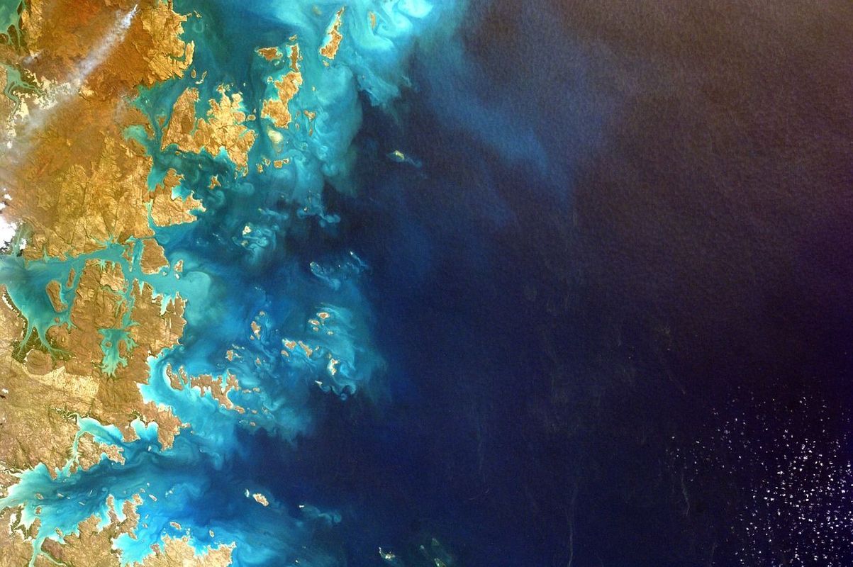
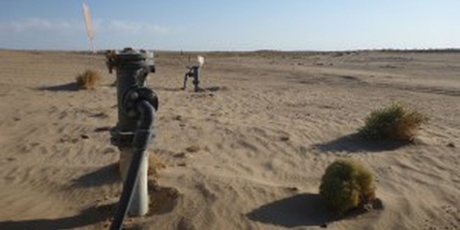
The AREVA in situ leaching operation site in Kazakhstan (Source: Vincent Lagneau).

This work has been successful: Vincent Lagneau’s team has succeeded in developing a predictive model, in partnership with AREVA, that was used operationally two years ago, in Kazakhstan. “Today, if someone gives me a site that has not yet been operated, I run my model and can tell what the production curve will be like and what the environmental impacts will be. It is really a key result for us.

Eventually, it will be possible to use the tool developed by Vincent Lagneau and his research team to choose the best location and injection solution to use in order to optimize the operation of the site, and will also enable the assessment of its impacts in advance. “We are now applying the model to prospective sites in Mongolia: we assess the fluid circulation in the environment up to the zones in which they could rise to the surface (wells, faults), and changes in its quality as it travels through the system (reduction of the acidity and residual uranium fixation).


Mines Douai, Concrete, sediments

Recycling concrete and sediment to create new materials

How can we meet the needs for construction materials in an environmentally responsible manner? Recycling could be the solution, but it is not yet easy to create high-performance and eco-friendly materials using waste. At the conference on Natural Resources and Environment, which took place on November 5-6 2014 at Institut Mines-Télécom, Vincent Thiéry, a researcher at Mines Douai, presented two aspects of the research developed in the Civil and Environmental Engineering department on designing the concrete of the future.


It is increasingly difficult to find high-quality raw materials to make materials like concrete. At the same time, we are generating more and more waste that we do not know how to dispose of – industrial by-products, concrete from building renovations or demolitions, and sediments that block ports and canals. Vincent Thiéry and his colleagues are therefore working to design alternative materials, such as concrete and cements, using these new raw materials whose potential remains unexplored: “One the one hand, we could generate less waste, and on the other hand, we wouldn’t have to use as many natural resources.


Recycling sediments and old concrete

Our mission is to create high-performance materials that are environmentally friendly. This can be accomplished through recycling, by incorporating a certain amount of waste into these materials.” The sediments are retrieved by dredging ports and canals every 10 to 20 years, which produces large quantities of materials. The construction materials sector is has many uses for the recovered sediments: “We will try to integrate them into the construction of roads, prefabricated concrete (casting of concrete blocks or concrete for street furniture), landscaped mounds, embankments, and in artificial aggregates for reinforcing beaches.” Another possibility is recycled concrete aggregate. 300 million tonnes of construction and demolition waste are generated each year, which can be reused as aggregate for producing concrete, even though this type of aggregate requires much more water than traditional concrete. Better yet, “certain industrial by-products and waste – typically those generated by the steel industry – are resources used in the cement industry: the integration of these materials can produce attractive results, such as resistance to seawater and good mechanical strength.


Vincent Thiéry, Mines Douai, concrete, sediments

Recycled concrete aggregate (diameter: approximately 1 cm). Black components: a natural aggregate. Gray components: cement paste. These two components behave differently when they are integrated into new concrete; they must be correctly characterized and quantified.

Recycling challenges: sustainable formulations

Scientific and technical challenges arise in relation to durability.” The dredged sediments contain heavy metals and organic pollutants, which must not be released into the environment: therefore, the stabilization of the recycled materials must be ensured. “Concrete that is poorly made can develop certain pathologies — which appear in the form of swelling, flaking, or crumbling — and can no longer be used for its intended purpose.” A very well known pathology – the alkali-silica reaction – has been one of the Civil and Environmental Engineering (GCE) department’s areas of expertise for around fifteen years. Not all types of aggregate cause this pathology, yet for some of them, a specific mineralogy must undergo extensive analysis to ensure it will not react. “Eventually, we will no longer have a choice; we will have to find ways of using them anyway. Fortunately, several types of industrial waste allow for the recycling of aggregates that could generate pathologies.

An example of microscopy applied to cementitious materials: a thin section of concrete. The colored components are the aggregates; the black part is the cement paste. The use of traditional optical microscopy (thin petrographic sections) makes it possible to compare the different components, thus facilitating their identification.

Prior research is required in order to find the right concrete formulation to match the intended use. “An extremely precise characterization of the recycled aggregate will be required before it can be integrated into new concrete.” Vincent Thiéry works on characterizing the materials, both natural and recycled. In other words, he uses microscopic observation to interpret the arrangement and properties of the minerals that compose the materials. “We know that in certain aggregates, we will need to look for a specific type of mineral, in a specific form, to determine if there is a risk of the concrete developing a pathology.

The laboratory has also developed an experimental method based on the dissolution of the cement paste hardened in salicylic acid to measure the percentage of cement in the recycled concrete. The lab features a mechanical characterization center and a digital simulation center.


Partnerships to move from fundamental research to applied research

The EcoSed (Sediments in a Circular Economy) Industrial Chair, launched in April 2014 by Mines Douai, will carry out partnership-based research over a 5-year period on the management of dredging sediments (ports and canals). The tonnages are significant – around 50 million metric tonnes per year in France. “It involves more fundamental aspects, like sediment characterization, before moving towards extremely practical and applied aspects”: developing materials, improving knowledge of sediment-based concrete, and improving knowledge of their behavior in road geotechnics, etc. It is one of the Civil and Environmental Engineering (GCE) department’s flagship projects. It is also participating in the national Recybéton project, which studies the use of materials from concrete recycling sites through experiments in the laboratory and at experimental construction sites.


Geological storage, stockage géologique

Geosciences and the environment: the challenges of geological storage

Geological storage is a field of expertise offered by the Institut Mines-Télécom schools’ research centers. During the Natural resources and environment conference held on November 5-6, 2014 at Institut Mines-Télécom, Vincent Lagneau, Assistant Director of the Mines ParisTech Research Center for Geosciences, spoke at a plenary session on “Underground storage and recycling”. He presented the benefits and key issues of R&D relating to storage in geological environments.


Gas, liquids or waste can be stored beneath our feet, in man-made cavities and in the voids of natural geological formations. In France, we have been storing natural gas for 60 years. “The underground environment offers two attractive assets for storage: the space and duration.” The volume available underground allows for the storage of enormous quantities of CO2, for example. And the storage time must range from a period of between 1,000 and 10,000 years for CO2, and between 100,000 and 1 million years for radioactive waste. “We do not have any example of human constructions that last for such a long period of time. However, we have examples of geological structures that are much older than these artefacts.


Understanding the impacts and creating reliable predictive models

Because we must use and disturb the underground environment for these storage purposes, we are faced with the difficulty of proving that these storage facilities are durable and do not impact the rest of the environment over the very long term.” However, while many studies have been carried out, they are limited in duration: the longest studies range from 10 to 20 years, and they are very rare. “Major scientific and technical challenges need to be overcome in order to understand the mechanisms,” in order to extrapolate how the storage sites will evolve in the very distant future. Multidisciplinary teams and striving to understand the processes that are taking place in the storage areas, in the field of radioactive waste at Mines ParisTech, Mines Douai and Mines Nantes, and acidic gases such as CO2 at Mines Saint-Etienne. They then establish predictive mathematical models that are used to determine the impacts, extrapolate the data observed in situ, and optimize the storage operations.


Challenges of storing renewable energies

Recent developments in the storage field are radically changing the current conception of underground storage. As renewable energies develop, society will face the problem of matching electricity supply and demand: a wind turbine only produces when there is wind, not because we need electricity. The underground environment can also provide interesting opportunities to address this energy storage problem: “We can store energy by transforming electricity into natural gas, which can then be burned in a classic thermal power plant. Mines schools are also working on storing energy via compressed air.

In this scenario, the storage is no longer used for large quantities over a very long period of time. The cavity is filled and emptied according to the rate of energy production and consumption. As a result, “the storage area will be used very frequently.” This is an altogether different matter, forcing researchers to think differently about the storage. “During the cycles we are considering, we will need to inject large quantities during the limited hours of production, which leads to mechanical problems.” This is why specialists from all the earth sciences – chemistry, geology, hydrogeology and geomechanics – have come together in the schools’ research centers to work on understanding the impacts of these new storage methods and model their development over the long term.


René Garello, Vigisat, Océan, Télécom Bretagne, Ocean

An ocean of environmental data to be processed

If nowadays we can detect icebergs along the route of the Vendée Globe, track and identify ships causing pollution from space, and define ecological corridors and reserves for the protection of animal species, it is largely thanks to stations which receive and process satellite images in real time, and the progress made in the last twenty years in the field of signal processing.

The creation of resources for environmental surveillance, sustainable management of marine resources and maritime safety is a key research priority of the Institut Mines-Télécom, and a field to which René Garello – a signal processing researcher at Télécom Bretagne, Director of GIS BreTel, and the recently elected president of the IEEE[1] OES (Oceanic Engineering Society) international academic association – has made major contributions.


Mapping, climate change, the battle against pollution, oceanography… a number of organizations working in these fields can be found in the city of Brest, with many of them collaborating at the Pôle Mer Bretagne competitiveness cluster, working together for a safe and sustainable maritime world. An expert at Pôle Mer and representative of the Brittany region for NEREUS (the Network of European Regions Using Space Technologies), René Garello is a key figure in this research community, covering both remote sensing and marine science.


Remote sensing and environmental observation

René Garello joined Télécom Bretagne in 1984, after three years at the NOAA (National Oceanic and Atmospheric Administration), the American agency responsible for the study of the ocean and the atmosphere. His thesis on radars for observation of the ocean surface led him to explore further practical applications, bringing valuable specialist skills to the agency.

Upon returning to France he continued to plough his own unique furrow, finding practical applications for scientific breakthroughs. While pursuing his research at Télécom Bretagne, the young researcher was also setting up European projects with German, British and Italian partners on marine surface observation and remote sensing. The first links were made with IFREMER (Institut Français de Recherche pour l’Exploitation de la Mer – French Research Institute for Exploitation of the Sea), which was commissioned by the IEEE OES with the organization of its flagship conference, OCEANS, in 1994. In 2005, René Garello chaired the second edition of the event in Brest.

The strength of his work lies in its two-dimensional approach to methods which were previously only used for one-dimension signal processing. “The starting point was signal processing, something which immediately interested me during my graduate studies, when I developed a particular interest in mathematics and its applications,” explains René Garello. Despite often relating to image-type data, this particular case was a question of two-dimensional signal processing as opposed to image processing.

Remote sensing is now carried out in ocean, coastal and inshore areas as well as both rural and urban areas for environmental purposes. VIGISAT (see text box) is a ground station for direct reception and analysis of satellite images, located in Brest and operated by CLS[2]. It provides ocean observation and surveillance services to a variety of organizations, including those responsible for government action at sea, defense, offshore construction, researchers and environmental associations…


[box type=”shadow” align=”” class=”” width=””]

Vigisat, René Garello, BreTel, Télécom Bretagne

The station for direct reception in Brest

VIGISAT, a station for direct reception and analysis of satellite images operated in Brest.

This cutting-edge facility was created by a Télécom Bretagne start-up called Boost Technologies, set up in 2001 by Professor Vincent Kerbaol, in which René Garello was a founding partner. A technology transfer partnership (for data processing software) was set up between Télécom Bretagne and Boost. The goal of this venture was to create a satellite radar receiving ground station in Brest, but such an infrastructure raised complex management issues (cost, maintenance, contracts with the European Space Agency) and the VIGISAT platform eventually came to fruition at the end of 2009, once Boost received backing from CLS. VIGISAT receives, processes, analyzes and distributes high-resolution radar images from European and Canadian satellites, 24 hours a day and in real time. Learn more [/box]


A constant interplay between theory and practice

René Garello’s main interest is still finding new applications for signal processing in the maritime context. “The marine surface is of great interest to a signal processing specialist, and it’s a useful subject to study: the sea provides a statistic that is non-Gaussian, non-stationary and non-linear. None of the models given to students are still applicable. For example, the noise model is not additive but multiplicative, there is nothing we can find in text books”, explains the professor.

The marine surface constitutes a film of water otherwise known as “surface roughness”. Waves, swells, eddies, wind and boats are visible through variation in roughness. The difficulty in processing these images arises when a sea is in motion which results in a Doppler effect (the shift in frequency of a wave between the levels recorded at emission and reception, when the distance between these two points changes over a period of time) before interpretation using signal processing statistical tools takes place: speed of wave movement, currents, boats. These speeds need to be taken into consideration in order to produce accurate images.

“The scientific advances we have made have been linked to the fact that we were looking for spatially distributed information, and wanted to work towards an extremely high-resolution,” explains René Garello. “We managed to get around the problem of non-stationary data using small, linear pieces.” But, bypassing the standard scientific approach, René did not just try out a few signal processing methods to see which one would work the most effectively. He began by looking closer at the physical nature of the phenomenon, and called in some specialist assistance.

“We rely on our knowledge of the geo-physical data, and of the instrument, the radar, which gives us a model which takes into consideration the physical nature of the phenomenon and sensor interaction.” This back and forth relationship between upstream research in signal processing and downstream research in marine science has led to progress in both fields.

One recent example arose from a simple question: how can we detect internal waves from space? Internal waves are a marine phenomenon, remaining beneath the surface and, through the vertical displacement of a mass of water, causing modifications to the surface roughness. These waves exert an influence on the water column: their energy can affect moored structures and they act as barriers to underwater communications. A European project (MORSE) driven by René Garello focused on analyzing radar images from periods of known internal wave activity, in order to be able to quantify: “We measured the wavelength and height of the internal wave on the radar image, and with the in situ measurements, we were able to validate the model which enabled us to experience the phenomenon in three-dimension.”

This desire to continuously compare research with the field of application is central in the the scientist activities for the IEEE. With the issues of climate change and energy-saving (oil, deep-sea exploration, offshore wind power) becoming ever more important, René Garello is steering the association towards further research on renewable marine energy, one of the key themes of the Pôle Mer Bretagne cluster and the IEED (Institut d’Excellence dans le domaine des Énergies Décarbonées – Institute of Excellence in the field of Decarbonated Energies) based in Brest.


René Garello, Télécom BretagneBorn in 1953 in the South of France, René Garello has spent his whole career in academia. Following a Master’s degree in Telecommunications in Toulon in 1977, he completed his Master of Advanced Studies and PhD at the INP Grenoble (Institut Polytechnique de Grenoble – Grenoble Polytechnic Institute of Technology). After joining Télécom Bretagne in 1984, he was appointed professor in 1988 and earned the Habilitation to Supervise Research in 1994. He was elected Fellow of the IEEE for his scientific research in 2006.

René Garello explains his commitment to the IEEE professional association: “The IEEE pushes us to prove that what we are doing is useful for humankind: it has a political commitment too, working with policy-makers, at a global level. Each researcher networks with contacts in their own country, so we have representative groups with an interest in maritime activities in most countries worldwide.” René was elected president of the IEEE OES (Oceanic Engineering Society) at the end of 2012, a responsibility which is rarely given to a non-American.

The researcher now divides his time between the IEEE and the research he is carrying out at TOMS (Traitements, Observation et Méthodes Statistiques – Processing, Observation and Statistical Methods) team at the Brittany-based Lab-STICC. Now a multi-administrative team (UBO, UBS, Télécom Bretagne, ENIB, ENSTA Bretagne), it has been rated A+ by the Agence d’Évaluation de la Recherche et de l’Enseignement Supérieur (AERES –Agency for the Assessment of Research and Higher Education) and brings together 20 professors and 25 PhD students.


[1] The Institute of Electrical and Electronics Engineers is a large organization which brings together over 400,000 members from more than 40 academic associations. The IEEE organizes 850 conferences each year, with 2 million documents, almost 150 journals and over 1,300 projects and standards under development. Now present in 160 countries, the institute is primarily led and managed by American nationals.

[2] A subsidiary of the CNES (Centre National d’Études Spatiales – National Centre for Space Studies) and IFREMER, CLS operates and processes data from over 80 instruments embedded in some forty satellites.