PREDIS

Innovating to improve radioactive waste management

The PREDIS European project aims to develop innovative activities for the management of radioactive waste, for which there is currently no solution. IMT Atlantique is one of the project’s seven work package leaders and will contribute to research on innovative approaches for the treatment and conditioning of metallic waste. Abdesselam Abdelouas, a researcher working on the project at IMT Atlantique, gives us an overview.


Can you describe the broader context for the PREDIS European project?

AA: The management of radioactive waste from the nuclear power cycle, as well as from other industries such as healthcare, radiopharmaceutical production, farming and mining operations, remains a challenge and requires the development of new methods, processes and technologies.

What is the project’s goal?

AA: The aim of PREDIS is to reduce the overall volume of waste destined for disposal and to recycle radioactively contaminated metallic waste. Reducing the volume of waste will make it possible to avoid building costly new disposal sites. The consortium will strive to test and assess innovative approaches  (methods, processes, technologies and demonstrators) for the treatment and conditioning of radioactive waste.

How do you plan to achieve this goal and what are the scientific hurdles to overcome?

AA: As part of this project, we’ll be selecting a well-known or new chemical process, improving it and adapting it for greater applicability. This process will also have to meet environmental requirements, in particular in regard to the toxicity of the materials used and the volume of effluents produced by the treatment.

How are IMT Atlantique researchers contributing to this project?

AA: Bernd Grambow and I are radiochemistry professors at IMT Atlantique’s Subatech laboratory, and we are coordinating Work Package 4 on metallic waste treatment. Beyond this coordination mission, we will be conducting research into decontamination and management of treatment effluents.

The PREDIS consortium brings together 48 partners. Which ones are you working with the most?

AA: In Work Package 4, we interact with some twenty mainly European partners, but we work more closely with the CEA (Marcoule), the University of Pannonia (Hungary) and the Czech Technical University (CTU).

What are the next big steps for the project?

AA: The PREDIS management team had been meeting on 16 June 2020 to prepare for the kick off meeting scheduled for September 2020.

Interview by Véronique Charlet for I’MTech


crisis

Crisis management: how to prepare local territories

The catastrophic wildfires in the Gard department last summer highlighted the fact that local territories must be prepared to handle natural disasters. Although certain reflexes never vary, each disaster is unique and requires a tailored response. Sophie Sauvagnargues, a researcher at IMT Mines Alès who specializes in local management of natural crises, is taking part in organizing exercises to help prepare local authorities for these situations.


Each crisis is unique. It is not possible for the local territories concerned to learn the correct method for resolving crises, since each response is suited to a particular situation. So, how can they prepare themselves for the unexpected? “There are essential skills and competencies to develop, in addition to organizational and management methods to ensure preparedness and response,” says Sophie Sauvagnargues. A researcher at IMT Mines Alès in natural crisis management, she is working with other researchers to develop “realistic, educational crisis exercises that are immersive and adaptive, so that local territories are better prepared to respond.”

As such, the researchers are working with local authorities (municipalities and inter-municipal bodies), industry players and institutional authorities to help them prepare for natural crises and learn how to manage them. Examples of such crises include forest fires or floods, such as occurred in the southern half of France in late November 2019. Some regions are at greater risk than others, and some accumulate several types of risks. Other regions anticipate the development of new risks, as the expected consequences of climate change. Mountain regions will prepare for torrential flooding due to rising water levels, while Reunion Island will anticipate the consequences of being hit by a cyclone.

The Alès researchers studied this latter example through the ANR SPICy project, in partnership with BRGM, Météo France-Indian Ocean, BRLIngénierie and LACy. The project, which was completed in 2017, is still being followed up with new crisis anticipation exercises in Reunion — the most recent of which date from November 2019. The researchers reach out to municipalities to work with them on developing appropriate tools for managing a cyclonic crisis. These tools are then used in a simulated situation.

Realistic exercises

It’s often the early stages of a crisis – mobilization and anticipation – that justify these exercises to the greatest extent,” says Sophie Sauvagnargues. The researcher and her colleagues carry out preliminary work to provide a detailed analysis of the present situation at the municipal level, then develop a tailored, fictional crisis-management scenario for each municipality and provide on-site support to play out this scenario. “The preparatory work needed to develop these exercises is extremely important,” she adds, “for these local crisis centers in Reunion Island, it went on for several months.” The scenario must reflect the context and reality, and be tailored for the organization in question.

One of the first steps is to gain a clear understanding of the context surrounding the requested exercise. This requires an in-depth understanding of the municipalities’ crisis organization and the position of the inter-municipal body with jurisdiction over this area. The learning objectives must also be determined in advance – if they have not been specified by the participants – as well as the phenomenon that would initiate the crisis. This involves analyzing what has worked and what hasn’t in previous crises to identify areas for improvement. “We design the scenarios with disruptive events calling for specific competencies and skills,” explains Sophie Sauvagnargues.

A great deal of documentation is required to ensure the credibility of these disruptive elements and the scenario as a whole. “For the ANR SPICy project in Reunion Island, we had to reconstruct an increasing cyclone warning level, at the meteorological and hydrological level,” says Sophie Sauvagnargues. “We worked with Météo France for the plausibility of cyclone activity, but the entire crisis had to be designed to reflect the geographic, meteorological and institutional situation.

Observing in order to correct

The exercises recreate a plausible, absorbing environment to immerse participants in a real-life situation for an hour and a half. Sophie Sauvagnargues and her team separate the participants and the organizers into two different rooms. It’s up to the participants to play out the sequences, by determining what actions and decisions should be taken to manage and anticipate the arrival of the cyclone and best prepare for it.

We stay in communication with them to support and guide them throughout the scenario,” explains Sophie Sauvagnargues. “That means being able to adapt to questions we hadn’t expected and keeping an interactive attitude while guiding them toward the intended learning goals.

The researchers also observe group dynamics, how decision-making is organized and collaboration. “We aren’t there to judge their decisions, but to assess a group and how it works,” she asserts. “That’s essential so that we may then discuss the exercise in terms of strengths and weakness, difficulties encountered, and their feelings in relation to the original objectives. Our goal is to take an objective look at how the exercise went.

New crisis management tools

As part of the SPICy project, we’ve developed Graduated Response Plans for the municipalities,” says Sophie Sauvagnargues. In addition to the Local Response Plan that at-risk municipalities are required to implement, the Graduated Response Plans divide the phases of crisis management into several scenarios. These scenarios have been calculated depending on the risks and evolve with the intensity of the crisis.

A plan has been established to suggest responses depending on each scenario. This may involve road blockades during floods, impacted areas, required immediate action such as neighborhoods to be warned first.

This Graduated Response Plan provides those involved in crisis management with a set of actions ready to go, so they won’t forget anything, by giving them more time to focus on the specific characteristics of the crisis,” adds Sophie Sauvagnargues. This is one example of a tool that can be developed through working with municipalities. In addition to training local authorities, crisis management exercises also provide an opportunity to develop tools to meet specific local needs.


Tiphaine Claveau for I’MTech

Image d'un globe terrestre vert - écoconception, eco-design

What is eco-design?

In industry, it is increasingly necessary to design products and services with concern and respect for environmental issues.  Such consideration is expressed through a practice that is gaining ground in a wide range of sectors: eco-design. Valérie Laforest, a researcher in environmental assessment and environmental engineering and organizations at Mines Saint-Étienne, explains the term.


What does eco-design mean?

Valérie Laforest: The principle of eco-design is to incorporate environmental considerations from the earliest stages of creating a service or product, meaning from the design stage. It’s a method governed by standards, at the national and international level, describing concepts and setting out current best practices for eco-design. We can just as well eco-design a building as we can a tee-shirt or a photocopying service.

Why this need to eco-design?

VL: There is no longer any doubt about the environmental pressure on the planet. Eco-design is one concrete way for us to think about how our actions impact the environment and consider alternatives to traditional production. Instead of producing, and then looking for solutions, it’s much more effective and efficient to ask questions from the design stage of a product to reduce or avoid the environmental impact.

What stages does eco-design apply to?

VL: In concrete terms, it’s based entirely on the life cycle of a system, from very early on in its existence. Eco-design thinking takes into account the extraction of raw materials, as well as the processing and use stages, until end of life. If we recover the product when it is no longer usable, to recycle it for example, that’s also an example of eco-design. As it stands today, end-of-life products are either sent to landfills, incinerated or recycled. Eco-design means thinking about the materials that can be used, but also thinking about how a product can be dismantled so as to be incorporated within another cycle.

When did we start hearing about this principle?

VL: The first tools arrived in the early 2000s but the concept may be older than that. Environmental issues and associated research have increased since 1990. But eco-design really emerged in a second phase when people started questioning the environmental impact of everyday things: our computer, sending an email, the difference between a polyester or cotton tee-shirt.

What eco-design tools are available for industry?

VL: The tools can fall into a number of categories. There are relatively simple ones, like check-lists or diagrams, while others are more complex. For example, there are life-cycle analysis tools to identify the environmental impacts, and software to incorporate environmental indicators in design tools. The latter require a certain degree of expertise in environmental assessment and a thorough understanding of environmental indicators. And developers and designers are not trained to use these kinds of tools.

Are there barriers to the development of this practice?

VL: There’s a real need to develop special tools for eco-design. Sure, some already exist, but they’re not really adapted to eco-design and can be hard to understand. This is part of our work as researchers, to develop new tools and methods for the environmental performance of human activities. For example, we’re working on projects with the Écoconception center, a key player in the Saint-Etienne region as well as at the national level.

In addition to tools, we also have to go visit companies to get things moving and see what’s holding them back. We have to consider how to train, change and push companies to get them to incorporate eco-design principles. It’s an entirely different way of thinking that requires an acceptance phase in order to rethink how they do things.

Is the circular economy a form of eco-design?

VL: Or is eco-design a form of the circular economy? That’s an important question, and answers vary depending on who you ask. Stakeholders who contribute to the circular economy will say that eco-design is part of this economy. And on the other side, eco-design will be seen as an initiator of the circular economy, since it provides a view of the circulation of material in order to reduce the environmental impact. What’s certain is that the two are linked.

Tiphaine Claveau for I’MTech

[box type=”info” align=”” class=”” width=””]

This article was published as part of Fondation Mines-Télécom‘s 2020 brochure series dedicated to sustainable digital technology and the impact of digital technology on the environment. Through a brochure, conference-debates, and events to promote science in conjunction with IMT, this series explores the uncertainties and challenges of the digital and environmental transitions.

[/box]


codling moth

A tribe of irreducible codling moths

In agriculture, biological alternatives to pesticides are being sought for environmental and health reasons. Use of a virus as a biocontrol agent for crop pests has become relatively widespread. One such example is Cydia pomonella granulovirus. It has been used for decades to target a crop pest that is fond of apples and pears: the codling moth. Miguel Lopez-Ferber, a researcher at IMT Mines Alès, has been working on this topic since 2005, the year in which the larvae of this insect developed resistance to a commercial product made from this granulovirus.


Cydia pomonella. Common name: codling moth. Adult moths measure approximately 18 millimeters long and are a brownish-gray color. Shortly after they hatch, larvae bore into orchard fruits and feed on them from the inside. The apples and pears are damaged and rot, so they are no longer suitable to be sold. However, these insects are very susceptible to a virus: their granulovirus, which is known as CpGV. If they come into contact with it, the larvae become ill and die, leaving the orchards healthy and untouched.

Unfortunately for apple trees, codling moths have developed resistance to CpGV, which poses a number of problems. For one, farmers need to find a new way to protect their orchards. And manufacturers need to determine whether it is possible to improve the viral preparation, find a substitute, or if production must be stopped. Then there’s the scientific question: “Codling moths have been in contact with this virus for millions of years and have never developed resistance to it. Why now?” wonders Miguel Lopez-Ferber, a researcher at IMT Mines Alès: “If there had been widespread resistance in the past, we would no longer find this virus in nature.” 

One possible explanation is that, “we’ve underestimated the inventiveness of nature,” says Miguel Lopez-Ferber. “We’ve acted as if it were a chemical product: for years, exactly the same viral solution has been spread over orchards.” In nature, when an insect repeatedly comes into contact with the same chemical product, it will adapt and find a way to resist it. So the product will no longer work as well. Viruses, on the other hand, will also adapt and find new ways to reach the insects if we don’t prevent them from doing so – they are in co-evolution.

“It works the same way with humans, with the flu virus, for example,” explains the researcher. “We develop defenses to protect ourselves from the virus, but it evolves and comes back stronger the next year.” And CpGV exists in different forms throughout the world. There are slight variations in genotype – which is the sum total of an individual’s genes. And the solution available on the market corresponds to the culmination of research on a single isolated genotype of this virus.

Research to overcome resistance

With CpGV, the same virus isolate has been applied massively for years. This means that it’s possible that codling moth larvae are not resistant to other isolates of the virus. The different genotypes of the virus have been divided into 5 groups, from A to E. The “A” group is most similar to the Mexican isolate, which has been used historically. The researchers found that the other groups infected resistant larvae. At the beginning, however, the other viral isolates were less effective than those originally used – a greater quantity of product was needed for the same plot of land. But with a little selection, the performance reached the same levels as that of the original product. “We were also worried that we would observe resistance to these new genotypes in the future,” says Miguel Lopez-Ferber. But it is likely that this resistance phenomenon will not appear if there is greater viral diversity.

The researchers therefore tried another method: they combined the Mexican isolate to which the larvae had become resistant, with another genotype of the virus that infected the larvae. And they discovered that together, the two were even more effective in infecting the larvae. In a way, the second genotype, “opened the door to the one that had been blocked until then,” explains Miguel Lopez-Ferber, “but we still don’t really understand how it works.” The researchers are therefore studying how the different forms of the virus interact with one another to infect larvae. They could then use this knowledge to develop one or several optimal mixtures, by appropriately combining the specific characteristics of each genotype.

“Viral diversity is an asset, but we don’t yet fully understand how it works,” explains the researcher. “Imagine, for example, if we wanted to colonize a desert island. If all the colonists were miners, there’d be a lack of skills for building houses, planting crops etc. We need different, complementary jobs. That’s what we get when we combine several genotypes of a virus – except we don’t really know what their jobs are. We just know they work better together.”

And studying the virus’s behavior in codling moth larvae is no simple task. Let’s say that a type A and type B virus are dispersed in an orchard. How can we determine if a larva has absorbed both forms of the virus or only a single form? Or, if one of them has prevented the other from developing? In order to understand how the tasks are distributed, the researchers would must able to track A and B as they colonize the larva. The molecular tools available today are not the best suited for this. Miguel Lopez-Ferber’s team is currently working in partnership with NeoVirTech, a Toulouse-based company, to develop a better technique for tracking viruses.

[box type=”info” align=”” class=”” width=””]

The origins of granulovirus

Using a natural predator to protect our harvests is not a new idea,” says Miguel Lopez-Ferber. “We domesticated cats to combat mice. It’s the same principle with granulovirus.”

It was in Mexico in 1964 that the codling moth granulovirus (CpGV) was discovered. Codling moth larvae were found dead and researchers sought to determine the cause. They then isolated the virus responsible: the Mexican isolate of CpGV. Shortly after, other forms of the virus were observed in Russia, followed by the United Kingdom. Slight variations existed between the viruses, subtle differences in genotype – the sum total of an individual’s genes. The Mexican isolate was favored for a potential commercial product because it was more homogenous. This made it easier to characterize in order to comply with regulatory criteria for insecticides, which are equivalent for phytosanitary and biological products and require rigorous identification of a product’s makeup.  

After 25 years of research, the viral solution was ready for use and authorized for sale. In practice, it is used like a chemical product. A concentrated liquid solution is prepared in a tank and is then dispersed in a spray of fine droplets, ideally covering the entire orchard in a uniform manner. Starting in the 1990s, the product was widely used and applied several times a year. Until 2005, that is, when it was observed that codling moths were still present after the treatment.[/box]

Véronique Bellon-Maurel

Véronique Bellon-Maurel: from infrared spectroscopy to digital agriculture

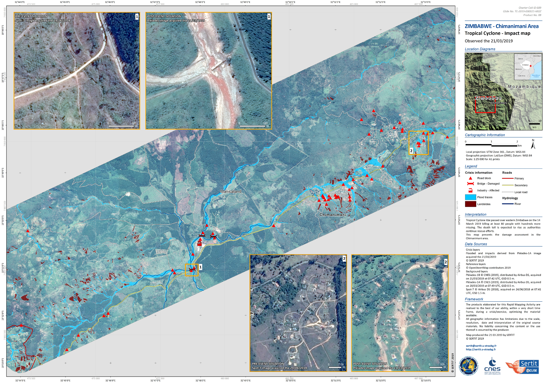
Measuring and quantifying have informed Véronique Bellon-Maurel’s entire scientific career. A pioneer in near infrared spectroscopy, the researcher’s work has ranged from analyzing fruit to digital agriculture. Over the course of her fundamental research, Véronique Bellon-Maurel has contributed to the optimization of many industrial processes. She is now the Director of #DigitAg, a multi-partner Convergence Lab, and is the winner of the 2019 IMT-Académie des Sciences Grand Prix. In this wide-ranging interview, she retraces the major steps of her career and discusses her seminal work.   


You began your research career by working with fruit. What did this research involve?

Véronique Bellon-Maurel: My thesis dealt with the issue of measuring the taste of fruit in sorting facilities. I had to meet industrial requirements, particularly in terms of speed: three pieces of fruit per second! The best approach was to use near infrared spectroscopy to measure the sugar level, which is indicative of taste. But when I was beginning my thesis in the late 1980s, it took spectrometers one to two minutes to scan a piece of fruit. I suggested working with very near infrared, meaning a different type of radiation than the infrared that had been used up to then, which made it possible to use new types of detectors that were very fast and inexpensive.

So that’s when you started working on near infrared spectroscopy (NIRS), which went on to became your specialization. Could you tell us what’s behind this technique with such a complex name?

VBM: Near infrared spectroscopy (NIRS) is a method for analyzing materials. It provides a simple way to obtain information about the chemical and physical characteristics of an object by illuminating it with infrared light, which will pass through the object and become charged with information. For example, when you place your finger on your phone’s flashlight, you’ll see a red light shining through it. This light is red because the hemoglobin has absorbed all the other colors of the original light. So this gives you information about the material the light has passed through. NIRS is the same thing, except that we use particular radiation with wavelengths that are located just beyond the visible spectrum.

Out of all the methods for analyzing materials, what makes NIRS unique?

VBM: Near infrared waves pass through materials easily. Much more easily than “traditional” infrared waves which are called “mid-infrared.” They are produced by simple sources such as sunlight or halogen lamps. The technique is therefore readily available and is not harmful: it is used on babies’ skulls to assess the oxygenation saturation of their brains! But when I was starting my career, there were major drawbacks to NIRS. The signal we obtain is extremely cluttered because it contains information about both the physical and chemical components of the object.

And what is hiding behind this “cluttered signal”?

VBM: In concrete terms, you obtain hill-shaped curves and the shape of these curves depends on both the object’s chemical composition and its physical characteristics. You’ll get a huge hill that is characteristic of water. And the signature peak of sugar, which allows you to calculate a fruit’s sugar level, is hidden behind it. That’s the chemical component of the spectrum obtained. But the size of the hills also depends on the physical characteristics of your material, such as the size of the particles or cells that make it up, physical interfaces — cell walls, corpuscles — the presence of air etc. Extracting solely the information we’re interested in is a real challenge!

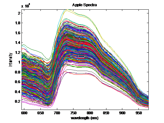
Near infrared spectrums of apples.


One of your earliest significant findings for NIRS was precisely that – separating the physical component from the chemical component on a spectrum. How did you do that?

VBM: The main issue at the beginning was to get away from the physical component, which can be quite a nuisance. For example, light passes through water, but not the foam in the water, which we see as white, even though they are the same molecules! Depending on whether or not the light passes through foam, the observation — and therefore the spectrum — will change completely. Fabien Chauchard was the first PhD student with whom I worked on this problem. To better understand this optical phenomenon, which is called diffusion, he went to the Lund Laser Center in Sweden. They have highly-specialized cameras: time-of-flight cameras, which operate at a very high speed and are able to capture photos “in flight.” We send photons onto a fruit in an extremely short period of time and we recover the photons as they come out since not all of them come out at the same time. In our experiments, if we place a transmitter and a receiver on a fruit spaced 6 millimeters apart, when they came out, certain photons had travelled over 20 centimeters! They had been reflected, refracted, diffracted etc. inside the fruit. They hadn’t travelled in a straight line at all. This gave rise to an innovation, spatially resolved spectroscopy (SRS) developed by the Indatech company that Fabien Chauchard started after completing his PhD.

We looked for other optical arrangements for separating the “chemical” component from the “physical” component. Another PhD student, Alexia Gobrecht, with whom I worked on soil, came up with the idea of using polarized near infrared light. If the photons penetrate the soil, they lose their polarization. Those that have only travelled on the surface conserve it. By differentiating between the two, we recover spectrums that only depend on the chemical component. This research on separating chemical and physical components was continued in the laboratory, even after I stopped working on it. Today, my colleagues are very good at identifying aspects that have to do with the physical component of the spectrum and those that have to do with to the chemical component. And it turns out that this physical component is useful! And to think that twenty years ago, our main focus was to get rid of it.

After this research, you transitioned from studying fruit to studying waste. Why did you change your area of application?

VBM: I’d been working with the company Pellenc SA on sorting fruit since around 1995, and then on detectors for grape ripeness. Over time, Pellenc transitioned to waste characterization for the purpose of sorting, based on the infrared knowledge developed through sorting fruit. They therefore called on us, with a new speed requirement, but this one was much tougher. A belt conveyor moves at a speed of several meters per second. In reality, the areas of application for my research were already varied. In 1994, while I was still working on fruit with Pellenc, I was also carrying out projects for biodegradable plastics. NIRS made it possible to provide quality measurements for a wide range of industrial processes. I was Ms. “Infrared sensors!”


“I was Ms. ‘Infrared sensors’!”
– Véronique Bellon-Maurel


Your work on plastics was among the first in the scientific community concerning biodegradability. What were your contributions in this area?

VBM: 1990 was the very beginning of biodegradable plastics. Our question was determining whether we could measure a plastic’s biodegradability in order to say for sure, “this plastic is truly biodegradable.” And to do so as quickly as possible, so why not use NIRS? But first, we had to define the notion of biodegradability, with a laboratory test. For 40 days, the plastics were put in reactors in contact with microorganisms, and we measured their degradation. We were also trying to determine whether this test was representative of biodegradability in real conditions, in the soil. We buried hundreds of samples in different plots of land in various regions and we dug them up every six months to compare real biodegradation and biodegradation in the laboratory. We wanted to the find out if the NIRS measurement was able to achieve the same result, which was estimating the degradation kinetics of a biodegradable plastic – and it worked. Ultimately, this benchmark research on the biodegradability of plastics contributed to the industrial production and deployment of the biodegradable plastics that are now found in supermarkets.

For that research, was your focus still on NIRS?

VBM: The crux of my research at that time was the rapid, non-destructive characterization — physical or chemical— of products. NIRS was a good tool for this. We used it again after that on dehydrated household waste in order to assess the anaerobic digestion potential of waste. With the laboratory of environmental biotechnology in Narbonne, and IMT Mines Alès, we developed a “flash” method to quickly determine the quantity of bio-methane that waste can release, using NIRS. This research was subsequently transferred to the Ondalys company, created by Sylvie Roussel, one of my former PhD students. My colleague Jean-Michel Roger is still working with them to do the same thing with raw waste, which is more difficult.

So you gradually moved from the agri-food industry to environmental issues?

VBM: I did, but it wasn’t just a matter of switching topics, it also involved a higher degree of complexity. In fruit, composition is restricted by genetics – each component can vary within a known range. With waste, that isn’t the case! This made environmental metrology more interesting than metrology for the food industry. And my work became even more complex when I started working on the topic of soil. I wondered whether it would be possible to easily measure the carbon content in soil. This took me to Australia, to a specialized laboratory at the University of Sydney. To my mind, all this different research is based on the same philosophy: if you want to improve something, you have to measure it!

So you no longer worked with NIRS after that time? 

VBM: A little less, since I changed from sensors to assessment. But even that was a sort of continuation: when sensors were no longer enough, how could we make measurements? We had to develop assessment methods. It’s very well to measure the biodegradability of a plastic, but is that enough to successfully determine if that biodegradable plastic has a low environmental impact? No, it isn’t – the entire system must be analyzed. I started working on life-cycle analysis (LCA) in Australia after realizing that LCA methods were not suited to agriculture: they did not account for water, or notions of using space. Based on this observation, we improved the LCA framework to develop the concept of a regional LCA, which didn’t exist at the time, allowing us to make an environmental assessment of a region and compare scenarios for how this region would evolve. What I found really interesting with this work was determining how to use data from information systems and sensors to build the most reliable and reproducible model as possible. I wanted the assessments to be as accurate as possible. This is what led me to my current field of research – digital agriculture.

Read more on I’MTech: The many layers of our environmental impact

In 2013 you founded #DigitAg, an institute dedicated to this topic. What research is carried out there?

VBM: The “Agriculture – Innovation 2025” report submitted to the French government in 2015 expresses a need to structure French research on digital agriculture. We took advantage of the opportunity to create Convergence Labs by founding the #DigitAg, Digital Agriculture Convergence Lab. It’s one of ten institutes funded by the Investments in the Future program. All of these institutes were created in order to carry out interdisciplinary research on a major emerging issue. At #DigitAg, we draw on engineering sciences, digital technology, biology, agronomy, economy, social sciences, humanities, management etc. Our aim is to establish knowledge bases to ensure that digital agriculture develops in a harmonious way. The challenge is to develop technologies but also to anticipate how they will be used and how such uses will transform agriculture – we have to predict how technologies will be used and the impacts they will have to help ensure ethical uses and prevent misuse. To this end, I’ve also set up a living lab, Occitanum — for Occitanie Digital Agroecology — set to start in mid-2020. The lab will bring together stakeholders to assess the use value of different technologies and understand innovation processes. It’s a different way of carrying out research and innovation, by incorporating the human dimension.

oil pollution

Marine oil pollution detected from space

Whether it is due to oil spills or cleaning out of tanks at sea, radar satellites can detect any oil slick on the ocean’s surface. Over 15 years ago, René Garello and his team from IMT Atlantique worked on the first proof of concept for this idea to monitor oil pollution from space. Today, they are continuing to work on this technology, which they now use in partnership with maritime law enforcement. René Garello explains to us how this technology works, and what is being done to continue improving it.

Most people think of oil pollution as oils spills, but is this the most serious form of marine oil pollution?

René Garello: The accidents which cause oil spills are spectacular, but rare. If we look at the amount of oil dumped into the seas and oceans, we can see that the main source of pollution comes from deliberate dumping or washing of tanks at sea. If we look at the amount of oil released over a year or a decade, this dumping releases 10 to 100 times more oil than oil spills. Although is does not get as much media coverage, the oil released by tank washing arrives on our coastlines in exactly the same way.

Are there ways of finding out which boats are washing out their tanks?

RG: By using sensors placed on satellites, we can have large-scale surveillance technology. The sensors allow us to monitor areas of approximately 100km². The maritime areas close to the coast are our priority, since this is where the tankers stay as they cannot sail on the high seas. Satellite detection methods have improved a lot over the past decade. 15 years ago, detecting tank dumping from space was a fundamental research issue. Today, the technology is used by state authorities to fight against this practice.

How does the satellite detection process work?

RG: The process uses imaging radar technology, which has been available in large quantities for research purposes since the 2000s. This is why IMT Atlantique [at the time called Télécom Bretagne] participated in the first fundamental work on large quantities of data around 20 years ago.  The satellites emit a radar wave towards the ocean’s surface, which is reflected back towards the satellite.  The reflection of the wave is different depending on the roughness of the water’s surface. The roughness is increased by things such as the wind, currents, or waves and decreased by cold water, algae masses, or oil produced by tank dumping. When the satellite receives the radar wave, it reconstructs an image of the water and displays the roughness of the surface.  Natural, accidental or deliberate incidents which reduce the roughness appear as a black mark on the image. The project is a European Research Project which is carried out in partnership with the European Space Agency and a startup based in our laboratories, Boost Technology – which has since been acquired by CLS – and has shown the importance of this technique for detecting oil slicks.

If several things can alter the roughness of the ocean’s surface, how do you differentiate an oil slick from an upwelling of cold water or algae?

RG: It is all about investigation. You can tell whether it is an oil slick from the size and shape of the black mark. Usually, the specialist photo-interpreter behind the screen has no doubt about the source of the mark, as an oil slick has a long, regular shape which is not similar to any natural phenomena. But this is not enough. We have to carry out rigorous tests before raising an alert. We cross-reference our observations with datasets to which we have direct access, such as the weather, temperature and state of the sea, wind, and algae cycles…. All of this has to be done within 30 minutes of the slick being discovered in order to alert the maritime police quickly enough for them to take action. This operational task is carried out by CLS, using the VIGISAT satellite radar data reception station that they operate in Brest, which also involves IMT Atlantique. As well as this, we also work with Ifremer, IRD and Météo France to make the investigation faster and more efficient for the operators.

Detecting an oil spill is one thing, but how easy is it to then find the boat responsible for the pollution?

RG: Radar technology and data cross-referencing allow us to identify an oil spill accurately. However, the radar doesn’t give a clear answer as to which boat is responsible for the pollution.  The transmission speed of the information sometimes allows the authorities to find the boat which is directly responsible, but sometimes we find the spill several hours after it has been created. To solve this problem, we cross-reference radar data with the Automatic Identification System for vessels, or AIS. Every boat has an AIS which provides GPS information about its location at sea. By identifying where the slick started and the time it was made, we can identify which boats were in the area at the time that could have done a tank dumping.

It is possible to identify a boat suspected of dumping (in green) amongst several vessels in the area (in red) using satellites.

It is possible to identify a boat suspected of dumping (in green) amongst several vessels in the area (in red) using satellites.


This requires knowing how to date back to when the slick was created and measuring how it changed at sea.

RG: We also work in partnership with oceanographers and geophysicists. How does a slick drift? How does its shape change over time? To answer these questions, we again use data about the currents and the wind. From this data, physicists use fluid mechanics models to predict how the sea would impact an oil slick. We are very good at retracing the evolution of the slick in the hour before it is detected. When we combine this with AIS data, we can eliminate vessels whose position at the time was incompatible with the behavior of the oil on the surface. We are currently trying to do this going further back in time.

Is this research specific to oil spills, or could it be applied to other subjects?

RG: We would like to use everything that we have developed for oil for other types of pollution. At the moment we are interested in sargassum, a type of brown seaweed which is often found on the coast. Its production increases with global warming. The sargassum invades the coastline and releases harmful gases when it decomposes. We want to know whether we can use radar imaging to detect it before it arrives on the beaches. Another issue that we’re working on involves micro-plastics. They cannot be detected by satellites. We are trying to find out whether they modify the characteristics of water in a way that we can identify using secondary phenomena, such as a change in the roughness of the surface. We are also interested in monitoring and predicting the movement of large marine debris…. The possibilities are endless!

Also read on I’MTech

nanoparticles

What happens to nanoparticles when they become waste?

For the past twenty years, industry sectors across the board have been producing a wide range of nanomaterials. They have developed rapidly and with little in the way of regulation. This has led to a regulatory vacuum when it comes to the end-of-life management of these nanomaterials. Little is known about the environmental and health impacts linked to the future of this nanowaste. IMT Atlantique researchers have therefore led two successive projects on the incineration of nanowaste as part of a research consortium: NanoFlueGas and Nano-Wet. The results confirm the persistence of certain nanoparticles after they leave the incinerator, in the form of effluent and ashes. Last April, the research consortium, made up of IMT Atlantique, INERIS and industrial partner Trédi – Groupe Séché Environnement, submitted its technical recommendations to ADEME. Researcher Aurélie Joubert, lead author of the Nano-Wet report and researcher at IMT Atlantique, provides a look back at how this pioneer program came about.


What was the purpose of the NanoFlueGas and Nano-Wet project?

Aurélie Joubert: There are currently no regulations on the management of nanoparticle waste, especially for end-of-life materials. If the nanoparticles contained in the waste are identified as being hazardous for the environment or health, this waste is categorized and treated in the hazardous waste cycle. If not, they follow the common domestic waste incineration cycle. Our goal was to understand what was happening to the nanoparticles over the course of this treatment, to determine whether the cycles are adapted to nanowaste and possibly how to optimize them.

During the NanoFlueGas project, we studied the incineration of nanowaste at temperatures of 850°C, which is the common practice in the domestic waste management cycle. A lab incineration furnace was developed for this purpose at INERIS. It reproduced the same conditions in terms of temperature, air turbulence and oxygen levels. We were able to confirm that nanoparticles were released during treatment at varying concentrations depending on the nature of the nanowaste being studied. We also observed a capture efficiency of over 99% of the nanoparticles released thanks to a system developed at IMT Atlantique: a pilot blowback bag filter.

During the second project, Nano-Wet, which ended on April 1st, we focused on the hazardous waste incineration cycle at 1,100°C and on a technique for the wet processing of smoke. ADEME, which funded the project, now has the results of this study, and they are now public.

Which types of nanowaste have you worked on, and where do they come from?

AJ: A national registry—called R-nano—has existed since 2013. It requires all nanoparticles present on French territory to be declared. We worked on actual waste deposits received by Trédi that are part of this registry. For the Nano-Wet project, we worked on chlorinated waste, which is waste produced during the manufacturing of PVC floor covering in the construction sector. We also had sulfur waste from ion exchange resin beads used for water treatment. Finally, we worked with organosilicon waste, in the form of a polymer from mastic, which we had already studied in the previous project and found to have high-emissivity.

We went through a fairly long and in-depth characterization phase for the types of waste selected. This was a choice we made and was unlike other research projects in which laboratories produce their own product and are therefore perfectly aware of its composition. We wanted to use real waste deposits, for which we did not know the exact composition, in order to develop relevant methodological tools for analysis. This could now allow industrialists like Trédi to identify the potential nanofillers in its waste in the lab, enabling them to remain in advance of the regulations in this area.

What were the findings from the Nano-Wet project?

AJ: For the incineration component, we observed different scenarios in the nanoparticles present in the smoke. This revealed that nanowaste behaves differently during incineration depending on the composition. With organosilicon polymer waste, the initial nanostructure of the silica is preserved. It even increases through the formation of nano-silica caused by the degradation of a polymer. Conversely, the nanostructure disappears in PVC waste. In the case of resin waste, which does not originally contain nanofiller, a nanostructure appears due to reactions involving the impurities that were present from the beginning.

The results also suggest that the “hazardous waste” cycle with incineration at 1,100°C should be applied to nanowaste. With the organosilicon polymer waste, we found that incineration at 1,100°C instead of 850°C reduced nanoparticle emissions due to a sintering phenomenon. This interesting finding could be applied to other types of waste. Concerning the smoke treatment system, we specifically focused on a device for treating gaseous pollutants: a washing column.  We showed that the washing column reduced the quantity of nanoparticle emissions by 60% after incineration. This column therefore significantly contributes to the overall effectiveness of the treatment system.

Why did you decide to focus on the water column smoke treatment process?

AJ: Both researchers and industrialists see scrubbers as an unusual process for nanoparticles, because they are normally used to treat acid gases in the smoke. With Nano-Wet, we demonstrated that they are still significantly effective with nanoparticles, reducing the quantity by 60%. This was a rather unexpected outcome, especially since it was obtained without optimizing the process: we studied the column’s effectiveness without adapting it to treat nanoparticles. Despite its effectiveness, it is important to maintain the complementary procedures designed specifically for particle collection, namely bag filters and electrostatic precipitators, which have an effectiveness of 99%. We are pioneers in this type of study and we will continue. We want to assess the influence of the operating conditions to improve the scrubbers’ effectiveness for nanoparticles, while maintaining their effectiveness with acid cases.

How did you go about studying the effectiveness of the water columns?

AJ: The idea was to build a water column that sprays fine droplets in our research facility. We developed our pilot test to enable us to work in realistic conditions in terms of temperature and humidity, but on a reduced scale. We kept the same turbulent flow regime, the same ratio between the flow of the liquid sprayed into the column and the air flow, the same size for the sprayed droplets, etc. Here we clearly witnessed the advantage of working with an industrialist on this project: Trédi provided us with the operating conditions in the form of technical specifications at the start of the project. However, we did simplify the experiment: the conditions are very complicated in the flue gas treatment lines because due to the large amount of acid gases. We made the decision to inject air enriched with nanoparticles without injecting corrosive acid gases like hydrochloric acid and sulfur dioxide.

Was it easy to transition from the laboratory to the industrial site?

AJ: When possible, we try to incorporate an on-site measurement phase in order to compare the laboratory scale with the real scale. In the context of the Nano-Wet project, a specialized team from INERIS conducted two measurement campaigns at the industrial site. They were faced with very complicated sampling conditions. Results from samples taken at the entrance to the water column allowed us to determine the particle size and concentration, conditions that we could then reproduce in the lab.

When the particles are removed from the column, they end up in the wastewater. What happens to them after that?

AJ: This is an issue that must be addressed. We did not identify the particles in the liquid phase after leaving the column.  We do not know what form they take, if they remain nanoparticles or if they agglomerate, in which case they could easily be separated in the water treatment station. Other research laboratories are working on these issues.

You just submitted your last report to ADEME. How could the legislation change?

AJ: The threshold values for particle emissions for waste incinerators are currently expressed in terms of total mass concentration in micrograms per cubic meter of air. This is not relevant for nanoparticles. Despite their negligible mass, they are suspected to be highly toxic. In the future, I think the standards could specify a concentration threshold in terms of quantity of particles, or in terms of mass according to the given particle size. For indoor air quality, for example, new tools have been developed to characterize mass concentrations by size of fine particulate matter: PM 10, PM 2.5 or PM 0.1.

This article was written (in Frenh) by Alice Mounissamy for I’MTech.

ALGIMEL is an environmentally-friendly material which is used in a wide range of projects.

ALGIMEL, a ‘marine’ polystyrene

In the future, materials will not only need to be more efficient; it will also be essential that they are environmentally friendly. With this in mind, researchers from IMT Mines Alès who specialize in bio-sourced materials are working on this project.  Over the past few decades, they have been trying to develop environmentally-friendly alternatives to the most polluting materials. One of their latest designs is a naturally occurring polymer foam which can replace several of polystyrene’s uses. Eric Guibal and Thierry Vincent tell us about their work.


What is the material you have developed like?

Eric Guibal: We see it as a material with similar properties to polystyrene. It is a low-density foam with a structure that is mainly made up of biopolymers. This material, named ALGIMEL, is mostly made up of alginate, a natural polymer which is found in the cell wall of brown algae. The team’s expertise is mainly focused on the synthesis and composition of these foams.

Why did you choose this type of biopolymer?

Thierry Vincent: From the beginning, our aim was to develop the most environmentally-friendly material possible. This decision goes far beyond the choice of polymer as during the synthesis of the material we don’t use any toxic products. For example, when we are developing the foam, we don’t use any chemical solvents.  We don’t use products which could be dangerous for the technicians. The additives which we use to improve the properties of the material are also natural. Our manufacturing processes have low energy consumption and the drying process is carried out at a maximum temperature of 50°C. Some synthetic products are still used during manufacturing, but they make up less than 1% of all the materials that we use, and we are working on replacing them with bio-sourced materials.

Why did you want to develop these foams?

EG: Our aim was to produce an insulating material which was also an alternative to polystyrene. This is because polystyrene takes several hundred years to biodegrade, pollutes water and releases several toxic substances when it burns. Although our biopolymer foam has similar thermal insulating properties to polystyrene, it is also different due to its outstanding fire-resistant properties. ALGIMEL also has a controlled lifespan. When it is being used, the material is stable; however, at the end of its life, its biodegradable properties mean that it can be put in the household compost.

What could this material be used for?

TV: This material is light and extremely versatile, which means it can have many uses. As well as its thermal insulation and flame-retardant properties, its surface properties can be modified by applying biopolymers which make the foam hydrophobic, so it can be used in humid environments. To increase its mechanical strength, you can easily add plant-based fibers or mineral fillers. We can also add pigments or dyes, both on the interior and the surface, to change its appearance. If it’s used with other materials such as wood, fabrics, leather, etc., either in its composite form or as a sandwich compound, the foam has many uses. These include decoration, packaging, bags, clips fashion and luxury items, etc.

How did your research lead you to this material?

TV: For around thirty years, our work has focused on developing biopolymers. Our main area of experience is with alginate, as well as other biopolymers such as chitin and chitosan, which are made from crustacean shells. We have always directed our research towards developing materials that are more environmentally friendly. ALGIMEL is the result of all the skills we have acquired during our research.

Will the material soon be used outside of your laboratory?

EG: We are currently working with organizations that specialize in technology transfer, including SATT AxLR Occitanie Est. We are also lucky enough to have a contract with Institut Carnot M.I.N.E.S and the Carnot Carats network. Today, we are in the process of raising process quality and pre-industrialization. In collaboration with several partners, we are working on improving the design of our foams so they can be used in decorative, fashion and luxury products. We know that the development of this type of material is in line with many announcements made by the public authorities and industrialists. The most recent example is Emmanuel Macron’s aim of making the fashion and luxury goods industries more sustainable, which he entrusted to François-Henri Pinault. All of this shows that this product has a promising future ahead of it.


plants

When plants help us fight pollution

To help reduce or stabilize soil and water pollution, plants provide a rather effective yet inexpensive solution. They must be implemented on a case-by-case basis and could be used in a wide variety of sites.


According to the French Environment and Energy Management Agency (Ademe), 300,000 to 400,000 industrial or mining sites in France are potentially polluted, which represents a total of approximately 100,000 hectares or the equivalent of 140,000 soccer fields. Many of these sites are considered “orphans” since they have no known owner.

How can they be cleaned up? The most radical solution is to remove the polluted soil and store it in a suitable landfill site. But this is also one of the worst choices, since it is extremely costly and more importantly, not environmentally-friendly: it takes thousands of years for soil to form! This solution is therefore reserved for instances in which there is a dire need for land and in which the polluted soil poses a significant health risk. For example, if there is a plan to build a school. In all other cases, a more gradual approach is preferable. Researchers at Mines Saint-Etienne are developing methods for removing heavy metals (primarily lead, cadmium, cobalt, nickel, zinc, copper, chromium and arsenic) using plants — which is referred to as phytoremediation.

There are two major techniques for treating polluted soil using phytoremediation. Phytoextraction consists of growing plant species that can accumulate large amounts of heavy metals and tolerate them well. These plants must then simply be cut back from time to time and the clippings must be burnt in specialized incinerators, to gradually extract these metals. However, this decontamination method is slow as it takes between 10 and 100 years to completely decontaminate a site.

The other technique is phytostabilization, an approach adopted by researchers at Saint-Étienne: instead of removing the metals, they are made less dangerous. To do so, the pollutants are stabilized in situ. “Pollutants are dangerous when they are mobile,” explains Olivier Faure, a researcher at Mines Saint-Étienne. “This is the case when they leach into the water table, when animals graze on grass that contains the pollutant or in the event of mechanical erosion. But pollutants that are “trapped” have no impact on living organisms.” Since every polluted site is unique, methods must be chosen on a case-by-case basis, after analyzing the risks, which depend on the type of pollutant, how mobile it is, and the nature of the land: clay or sandy, acidic or basic, level of organic materials etc.  Phytostabilization is mainly used on large uninhabited sites.

Trapping the pollution involves growing plants that accumulate the pollutants as little as possible, but which are able to resist them. It is thus the opposite of phytoextraction. These plants prevent wind and precipitation erosion and absorb a portion of the water, meaning that it will not find its way into the water table. In addition, their root systems change soil properties by stimulating microorganisms and by changing the chemical form of pollutants, which makes them less mobile. “These plants bring soil back to life, even if we do not yet understand all the mechanisms,” observes Olivier Faure. The researchers combine grasses, which quickly cover the soil, with legumes such as alfalfa, which fix the nitrogen in the air and enrich the soil. They sometimes add other species to enhance biodiversity, for example, plants in the Asteraceae family like dandelions, which attract pollinating  insects.

These phytostabilization techniques have been tested to rehabilitate slag heaps, accumulations of waste from the metal industry which are rich in metal. “These slag heaps are largely inhospitable for plants since they contain very little organic matter or nitrogen and drain the water,” explains the researcher. “In partnership with Arcelor Mittal, we’ve developed a revegetation process which can be applied to this type of slag heap as part of the ANR program called Physafimm. To help establish the species, we restimulate soil development by providing ‘materials of agricultural value resulting from water treatment,’ which consist of sludge from water treatment plants composted with organic waste. We reach a vegetation recovery rate of 100 %.”

Cleaning up polluted water with floating wetlands

Using plants to clean up pollution is not limited to soil. Water can also be contaminated with hydrocarbons, suspended solids or metals. This is the case for example, for rainwater retention basins near highways. Researchers at IMT Atlantique are working on a simple solution: installing floating  mats which incorporate plants (commonly known as “floating wetlands”). The roots develop in the fibrous mat and reach the water, where they form an extensive network. They serve a number of purposes: they act as a physical filter for specific pollutants and provide surface area to support the development of bacteria that break down or trap undesirables.

Karine Borne, who is now a researcher at IMT Atlantique, tested this solution at the University of Auckland in New Zealand, with a plant called Carex virgata. “Compared to a control basin without plants, we observed an additional reduction of 40% for suspended solids and good results for copper and zinc,” she says. “These results are completely transposable to France, especially in Brittany, where there’s a similar climate.” Such a reduction, even if it is only partial, often  makes it possible to remain below the European limit values for good water quality.

Placed in the middle of a stream, the floating wetland traps heavy metals, in particular copper and zinc.


This system is easy to maintain. The above-ground parts of plants can be cut once a year to make them stronger. The roots die, break off and settle in the basin, along with the contaminants, to such an extent that it must be dredged more frequently. The sediments are analyzed, and depending on their toxicity level, are either recovered or sent to the landfill in accordance with the legislation.

In addition to stormwater remediation, this technique can be used as a tertiary treatment in industrial or domestic water treatment plants, following traditional treatment. This is especially important in summer, when rivers have low flows and are therefore vulnerable to the slightest pollution. Industrial facilities must therefore wait for autumn to discharge this water, which means they have to build huge storage lagoons.  The plant-based solution is much easier to implement and it requires very little civil engineering.

Whether they are used for soil or water, plants are important allies in the fight against pollution. The solution must now be scaled up to an industrial level. “For soil, we’re at a pivotal stage between R&D and the first commercialized applications,”  says Olivier Faure. “The Ademe encourages these approaches, with numerous calls for projects, but there are still some administrative and regulatory obstacles to overcome. The Regional Directorates for the Environment, Land Planning and Housing (DREAL) must approve the applications. They are reluctant for the moment, but should quickly change their position.”

Meanwhile, in January Karine Borne started research with her colleagues from the Energy Systems and Environment Department in collaboration with SVITEC, as part of the ANR FloWAT project. The aim is to test the water remediation technique as a tertiary treatment for the agrifood industry (slaughterhouses and poultry). There is still a long way to go before these techniques can be used on an industrial scale that is fully able to meet the challenges ahead.

Article written (in French) by Cécile Michaut, for I’MTech.


SERTIT

SERTIT: satellite imagery for the environment and crisis management

I’MTech is dedicating a series of stories to success stories from research partnerships supported by the Carnot Télécom & Société Numérique Institute (TSN), to which Télécom Physique Strasbourg and IMT belong.

[divider style=”normal” top=”20″ bottom=”20″]

Belles histoires, Bouton, CarnotThe regional image processing and remote sensing service (SERTIT) has specialized in producing geographic information production for over 30 years. It is linked with the ICube[1] laboratory, a key partner for Télécom Physique Strasbourg, and is part of the Carnot Télécom & Société Numérique Institute’s technology platform offer. Its role is to transform raw satellite images into a useful source of information to provide insights into regional land planning, environmental and biodiversity management, or rescue and relief operations in response to natural disasters. Mathilde Caspard, a remote sensing engineer at SERTIT, explains the platform’s various activities.


The SERTIT platform makes it possible to produce geographical information: what does this involve?

Mathilde Caspard: We mainly use satellite images, which we analyze and use to obtain information to help different actors make decisions. Our service makes it possible, for example, to map the forest cover or bodies of water. We can therefore inform land planning choices by providing information about the environment. We also have applications linked to crisis management following natural disasters such as floods, fires, hurricanes etc.

What role does the platform play in crisis management?

MC: We take part in rapid mapping operations. These actions make it possible to quickly deploy satellites to produce post-event maps in a short time frame. The satellite images are used to extract geographical information about the events. This information is then provided to the agencies which manage relief operations. We contribute to such efforts in particular through the COPERNICUS Emergency Management Service (EMS) European program. If there were to be major flooding in France for example, the authorized French user, the General Directorate for Civil Security and Crisis Management (DGSCGC), would request that the European Union activate the emergency rapid mapping service. If the request is accepted, the European program calls on our services. We must then provide information about the extension of the flooding, road and bridge conditions, submerged buildings etc. in less than ten hours’ time. The SERTIT rapid mapping service, which is certified ISO 9001, is available 365 days a year, and 24 hours a day for this type of mission.

In concrete terms, how do you ensure that SERTIT can respond to the request so quickly?

MC: As soon as we receive satellite data, we begin the image processing steps. We’ve been in existence since 1986, so we’ve developed numerous tools to speed up production. For example, we have algorithms that allow us to quickly extract bodies of water in images. In the event of forest fires, other algorithms help us identify burnt areas and untouched areas. Then, we cross-check this information with other sources of data, such maps made before the disaster. This helps us identify destroyed buildings, or unusable roads. Once all this information has been extracted, we deliver information in the form of a map and files that decision-makers can use directly in their systems to organize relief efforts.

This example of a map produced by SERTIT illustrates the type of geographical information it can provide.  The map shows the region surrounding Chimanimani in Zimbabwe, on 21 March 2019, following a tropical cyclone. SERTIT identifies blocked or unusable roads,  damaged bridges, affected industrial zones, flooded areas etc.

This example of a map produced by SERTIT illustrates the type of geographical information it can provide. The map shows the region surrounding Chimanimani in Zimbabwe, on 21 March 2019, following a tropical cyclone. SERTIT identifies blocked or unusable roads, damaged bridges, affected industrial zones, flooded areas etc.

Do you only intervene in disasters that affect France?  

MC : The European COPERNICUS EMS program is a consortium made up of several production sites spread out over France, Italy, Germany and Spain. Depending on the number and magnitude of the events, the services of several production sites can be called on at the same time. Our services may just as likely be called upon for disasters in France and in Europe as they may be for events elsewhere in the world. The European Commission may provide assistance to countries outside the European Union which are affected by natural disaster.  In such cases, it calls on its rapid mapping service, since it must be able to determine how much assistance is required. Recently, for example we’ve worked on a cyclone in Mozambique, another in Australia, flooding in Iran, and fires in Kenya.

When SERTIT is not working on crisis management, what do the platform’s activities involve?

MC: We have a wide range of environmental applications. For example, we are frequently asked to carry out forest cover mapping. We quantify the clearings and deforestation at a given moment and compare it to previous data to track it over time . In Alsace we’re in frequent contact with foresters since they then integrate this data in their decision support tools to guide their cutting and forest maintenance as a result. In the same way, we measure urban areas to help local authorities with land planning. These are SERTIT’s long-standing activities. And we also receive occasional requests, for example, for specific biodiversity monitoring.

How do satellite images help monitor biodiversity?

MC: A good example is our work to help protect the European hamster. It’s an endangered species in our region since its habitat is threatened. An official program has been put in place to help reintroduce the hamster. Associations have worked to identify burrows and mark them with GPS coordinates. For our part, we have created survival indicators based on the geographic information associated with these GPS coordinates. For example, the hamster feeds exclusively on wheat and alfalfa and does not travel more than 300 meters from its burrow. We therefore assessed the areas in which hamsters emerging from hibernation were most likely to survive, based on the burrows’ surroundings. In addition to this activity, we’ve also worked on fine-scale vegetation for the mapping the Eurométropole de Strasbourg. These maps were used to create  ecological corridors allowing for the movement of species in urban areas.

Where does the satellite data that you use for SERIT’s various applications come from? 

MC: The European COPERNICUS program has a fleet of Earth observation satellites with various characteristics — not just for rapid mapping for disasters.  This is somewhat unique in the world because the images are free as well. However, they aren’t always very high-resolution images. So, at the same time, we also use commercial images provided by companies such as Airbus or DigitalGlobe, whose images are much higher-resolution. It all depends on the desired objective: rapid image capture, wide field, accuracy etc. And in certain rapid mapping cases, in addition to all this, we also have at our disposal images acquired through the “International Space and Major Disasters Charter” which brings together 16 space agencies. It allows for international collaboration to provide free satellite images to best contribute to relief efforts.

[1] ICube is a joint research unit between University of Strasbourg/CNRS/ENGEES/INSA Strasbourg.

[box type=”shadow” align=”” class=”” width=””]

A guarantee of excellence
in partnership-based research since 2006


Having first received the Carnot label in 2006, the Télécom & Société numérique Carnot institute is the first national “Information and Communication Science and Technology” Carnot institute. Home to over 2,000 researchers, it is focused on the technical, economic and social implications of the digital transition. In 2016, the Carnot label was renewed for the second consecutive time, demonstrating the quality of the innovations produced through the collaborations between researchers and companies.

The institute encompasses Télécom ParisTech, IMT Atlantique, Télécom SudParis, Institut Mines-Télécom Business School, Eurecom, Télécom Physique Strasbourg and Télécom Saint-Étienne, École Polytechnique (Lix and CMAP laboratories), Strate École de Design and Femto Engineering. Learn more [/box]